You are here: Home > Network List > CI - Caltech Regional Seismic Network Stations List
> Station CIA Catalina Island Airport, California, USA > Earthquake Result Viewer
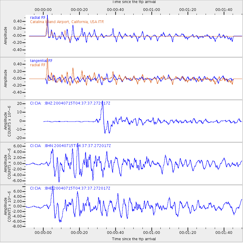
CIA Catalina Island Airport, California, USA - Earthquake Result Viewer
*The percent match for this event was below the threshold and hence no stack was calculated.
| Earthquake location: |
Fiji Islands Region |
| Earthquake latitude/longitude: |
-17.6/-178.6 |
| Earthquake time(UTC): |
2004/07/15 (197) 04:27:12 GMT |
| Earthquake Depth: |
560 km |
| Earthquake Magnitude: |
5.5 MB |
| Earthquake Catalog/Contributor: |
WHDF/NEIC |
|
| Network: |
CI Caltech Regional Seismic Network |
| Station: |
CIA Catalina Island Airport, California, USA |
| Lat/Lon: |
33.40 N/118.42 W |
| Elevation: |
428 m |
|
| Distance: |
76.6 deg |
| Az: |
48.26 deg |
| Baz: |
238.275 deg |
| Ray Param: |
$rayparam |
*The percent match for this event was below the threshold and hence was not used in the summary stack. |
|
| Radial Match: |
85.612076 % |
| Radial Bump: |
400 |
| Transverse Match: |
81.494255 % |
| Transverse Bump: |
400 |
| SOD ConfigId: |
2459 |
| Insert Time: |
2010-02-25 21:00:57.813 +0000 |
| GWidth: |
2.5 |
| Max Bumps: |
400 |
| Tol: |
0.001 |
|
Signal To Noise
| Channel | StoN | STA | LTA |
| CI:CIA: :BHN:20040715T04:37:37.272017Z | 6.8696957 | 1.4370336E-6 | 2.0918446E-7 |
| CI:CIA: :BHE:20040715T04:37:37.272017Z | 11.528932 | 1.6931117E-6 | 1.4685763E-7 |
| CI:CIA: :BHZ:20040715T04:37:37.272017Z | 26.894073 | 5.3854264E-6 | 2.0024585E-7 |
| Arrivals |
| Ps | |
| PpPs | |
| PsPs/PpSs | |


