You are here: Home > Network List > II - Global Seismograph Network (GSN - IRIS/IDA) Stations List
> Station BFO Black Forest Observatory, Schiltach, Germany > Earthquake Result Viewer
BFO Black Forest Observatory, Schiltach, Germany - Earthquake Result Viewer
| Earthquake location: |
Guerrero, Mexico |
| Earthquake latitude/longitude: |
18.6/-101.1 |
| Earthquake time(UTC): |
2006/08/11 (223) 14:30:40 GMT |
| Earthquake Depth: |
60 km |
| Earthquake Magnitude: |
6.0 MB, 6.1 MW, 6.0 MW |
| Earthquake Catalog/Contributor: |
WHDF/NEIC |
|
| Network: |
II Global Seismograph Network (GSN - IRIS/IDA) |
| Station: |
BFO Black Forest Observatory, Schiltach, Germany |
| Lat/Lon: |
48.33 N/8.33 E |
| Elevation: |
589 m |
|
| Distance: |
88.5 deg |
| Az: |
39.024 deg |
| Baz: |
296.479 deg |
| Ray Param: |
0.04240178 |
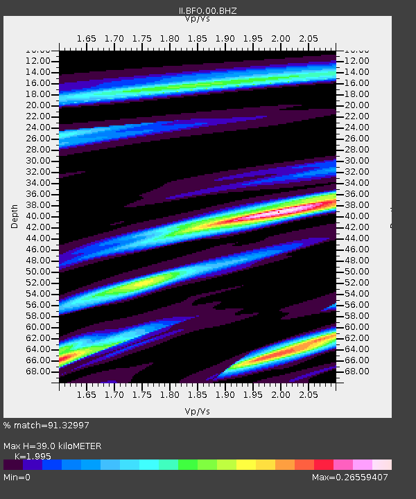
| Estimated Moho Depth: |
39.0 km |
| Estimated Crust Vp/Vs: |
2.00 |
| Assumed Crust Vp: |
6.264 km/s |
| Estimated Crust Vs: |
3.14 km/s |
| Estimated Crust Poisson's Ratio: |
0.33 |
|
| Radial Match: |
91.32997 % |
| Radial Bump: |
193 |
| Transverse Match: |
71.31367 % |
| Transverse Bump: |
251 |
| SOD ConfigId: |
2665 |
| Insert Time: |
2010-03-01 20:44:53.600 +0000 |
| GWidth: |
2.5 |
| Max Bumps: |
400 |
| Tol: |
0.001 |
|

Signal To Noise
| Channel | StoN | STA | LTA |
| II:BFO:00:BHN:20060811T14:42:55.604011Z | 0.71100825 | 4.066874E-8 | 5.7198694E-8 |
| II:BFO:00:BHE:20060811T14:42:55.604011Z | 1.601565 | 8.735749E-8 | 5.454508E-8 |
| II:BFO:00:BHZ:20060811T14:42:55.604011Z | 4.115773 | 2.2706595E-7 | 5.5169696E-8 |
| Arrivals |
| Ps | 6.3 SECOND |
| PpPs | 18 SECOND |
| PsPs/PpSs | 25 SECOND |


