You are here: Home > Network List > LD - Lamont-Doherty Cooperative Seismographic Network Stations List
> Station KSCT Kent School, Kent, Conneticut > Earthquake Result Viewer
KSCT Kent School, Kent, Conneticut - Earthquake Result Viewer
| Earthquake location: |
Near Coast Of Nicaragua |
| Earthquake latitude/longitude: |
11.6/-86.0 |
| Earthquake time(UTC): |
2014/04/11 (101) 20:29:13 GMT |
| Earthquake Depth: |
135 km |
| Earthquake Magnitude: |
6.6 MWW, 6.6 MWC, 6.6 MWB, 6.6 MI |
| Earthquake Catalog/Contributor: |
NEIC PDE/NEIC COMCAT |
|
| Network: |
LD Lamont-Doherty Cooperative Seismographic Network |
| Station: |
KSCT Kent School, Kent, Conneticut |
| Lat/Lon: |
41.73 N/73.48 W |
| Elevation: |
114 m |
|
| Distance: |
32.0 deg |
| Az: |
17.898 deg |
| Baz: |
203.722 deg |
| Ray Param: |
0.07847326 |
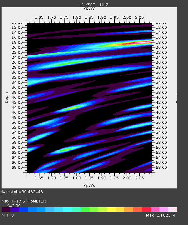
| Estimated Moho Depth: |
17.5 km |
| Estimated Crust Vp/Vs: |
2.09 |
| Assumed Crust Vp: |
6.472 km/s |
| Estimated Crust Vs: |
3.097 km/s |
| Estimated Crust Poisson's Ratio: |
0.35 |
|
| Radial Match: |
90.453445 % |
| Radial Bump: |
400 |
| Transverse Match: |
83.638885 % |
| Transverse Bump: |
400 |
| SOD ConfigId: |
626651 |
| Insert Time: |
2014-04-25 20:59:50.687 +0000 |
| GWidth: |
2.5 |
| Max Bumps: |
400 |
| Tol: |
0.001 |
|

Signal To Noise
| Channel | StoN | STA | LTA |
| LD:KSCT: :HHZ:20140411T20:34:56.059991Z | 26.518887 | 5.319609E-6 | 2.00597E-7 |
| LD:KSCT: :HHN:20140411T20:34:56.059991Z | 18.884617 | 3.815317E-6 | 2.0203306E-7 |
| LD:KSCT: :HHE:20140411T20:34:56.059991Z | 4.9133015 | 4.2826537E-6 | 8.716448E-7 |
| Arrivals |
| Ps | 3.2 SECOND |
| PpPs | 7.8 SECOND |
| PsPs/PpSs | 11 SECOND |


