You are here: Home > Network List > LD - Lamont-Doherty Cooperative Seismographic Network Stations List
> Station TUPA Temple University, Pennsylvania > Earthquake Result Viewer
TUPA Temple University, Pennsylvania - Earthquake Result Viewer
| Earthquake location: |
Near Coast Of Nicaragua |
| Earthquake latitude/longitude: |
11.6/-86.0 |
| Earthquake time(UTC): |
2014/04/11 (101) 20:29:13 GMT |
| Earthquake Depth: |
135 km |
| Earthquake Magnitude: |
6.6 MWW, 6.6 MWC, 6.6 MWB, 6.6 MI |
| Earthquake Catalog/Contributor: |
NEIC PDE/NEIC COMCAT |
|
| Network: |
LD Lamont-Doherty Cooperative Seismographic Network |
| Station: |
TUPA Temple University, Pennsylvania |
| Lat/Lon: |
40.17 N/75.19 W |
| Elevation: |
112 m |
|
| Distance: |
30.0 deg |
| Az: |
16.755 deg |
| Baz: |
201.63 deg |
| Ray Param: |
0.07920114 |
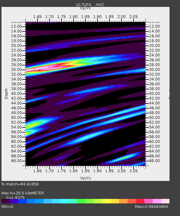
| Estimated Moho Depth: |
29.5 km |
| Estimated Crust Vp/Vs: |
1.64 |
| Assumed Crust Vp: |
6.283 km/s |
| Estimated Crust Vs: |
3.837 km/s |
| Estimated Crust Poisson's Ratio: |
0.20 |
|
| Radial Match: |
94.61858 % |
| Radial Bump: |
212 |
| Transverse Match: |
71.69441 % |
| Transverse Bump: |
390 |
| SOD ConfigId: |
626651 |
| Insert Time: |
2014-04-25 21:00:16.437 +0000 |
| GWidth: |
2.5 |
| Max Bumps: |
400 |
| Tol: |
0.001 |
|
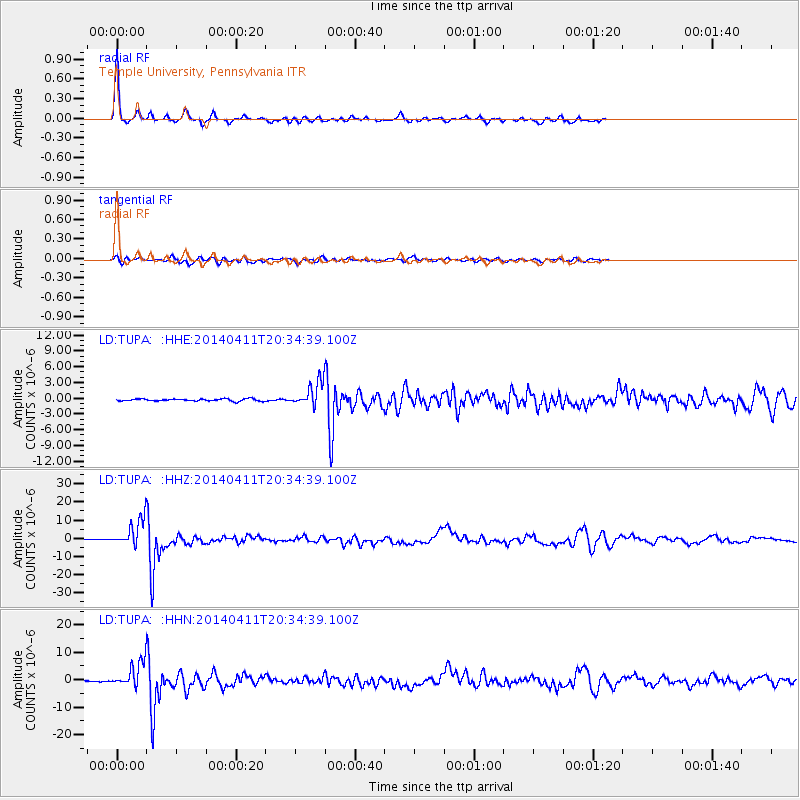
Signal To Noise
| Channel | StoN | STA | LTA |
| LD:TUPA: :HHZ:20140411T20:34:39.100Z | 41.465336 | 7.0577285E-6 | 1.7020791E-7 |
| LD:TUPA: :HHN:20140411T20:34:39.100Z | 20.248823 | 4.3277278E-6 | 2.1372738E-7 |
| LD:TUPA: :HHE:20140411T20:34:39.100Z | 10.72576 | 2.2348818E-6 | 2.083658E-7 |
| Arrivals |
| Ps | 3.3 SECOND |
| PpPs | 11 SECOND |
| PsPs/PpSs | 15 SECOND |


