You are here: Home > Network List > PE - Penn State Network Stations List
> Station PSWB Penn State Wilkes-Barre > Earthquake Result Viewer
PSWB Penn State Wilkes-Barre - Earthquake Result Viewer
| Earthquake location: |
Near Coast Of Nicaragua |
| Earthquake latitude/longitude: |
11.6/-86.0 |
| Earthquake time(UTC): |
2014/04/11 (101) 20:29:13 GMT |
| Earthquake Depth: |
135 km |
| Earthquake Magnitude: |
6.6 MWW, 6.6 MWC, 6.6 MWB, 6.6 MI |
| Earthquake Catalog/Contributor: |
NEIC PDE/NEIC COMCAT |
|
| Network: |
PE Penn State Network |
| Station: |
PSWB Penn State Wilkes-Barre |
| Lat/Lon: |
41.31 N/76.02 W |
| Elevation: |
398 m |
|
| Distance: |
30.9 deg |
| Az: |
14.804 deg |
| Baz: |
199.41 deg |
| Ray Param: |
0.07893304 |
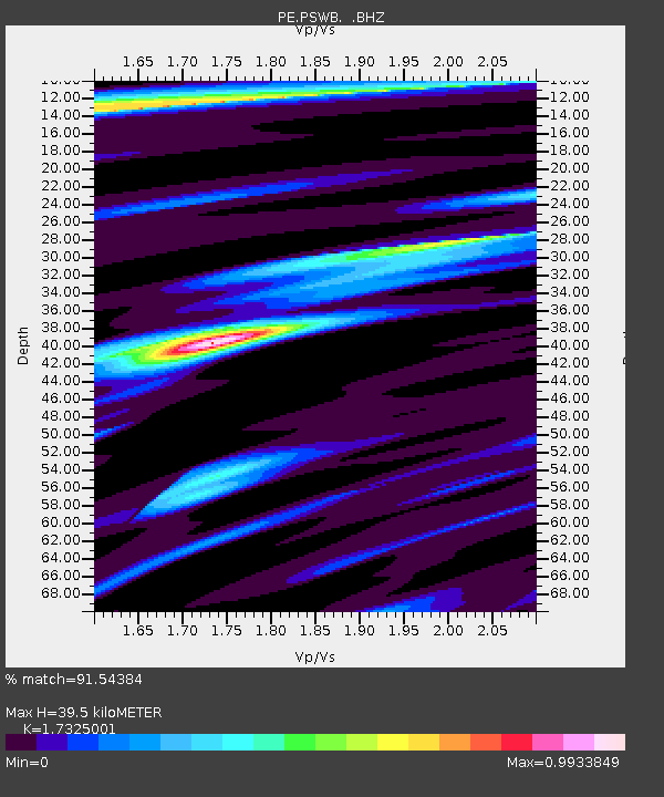
| Estimated Moho Depth: |
39.5 km |
| Estimated Crust Vp/Vs: |
1.73 |
| Assumed Crust Vp: |
6.121 km/s |
| Estimated Crust Vs: |
3.533 km/s |
| Estimated Crust Poisson's Ratio: |
0.25 |
|
| Radial Match: |
91.54384 % |
| Radial Bump: |
342 |
| Transverse Match: |
71.32929 % |
| Transverse Bump: |
400 |
| SOD ConfigId: |
626651 |
| Insert Time: |
2014-04-25 21:03:33.395 +0000 |
| GWidth: |
2.5 |
| Max Bumps: |
400 |
| Tol: |
0.001 |
|

Signal To Noise
| Channel | StoN | STA | LTA |
| PE:PSWB: :BHZ:20140411T20:34:46.540002Z | 25.442617 | 8.162116E-6 | 3.2080487E-7 |
| PE:PSWB: :BHN:20140411T20:34:46.540002Z | 18.778275 | 4.5287757E-6 | 2.4117102E-7 |
| PE:PSWB: :BHE:20140411T20:34:46.540002Z | 3.6005447 | 1.006453E-6 | 2.7952797E-7 |
| Arrivals |
| Ps | 5.1 SECOND |
| PpPs | 16 SECOND |
| PsPs/PpSs | 21 SECOND |


