You are here: Home > Network List > TA - USArray Transportable Network (new EarthScope stations) Stations List
> Station D62A Allapoint, Allagash, ME, USA > Earthquake Result Viewer
D62A Allapoint, Allagash, ME, USA - Earthquake Result Viewer
| Earthquake location: |
Near Coast Of Nicaragua |
| Earthquake latitude/longitude: |
11.6/-86.0 |
| Earthquake time(UTC): |
2014/04/11 (101) 20:29:13 GMT |
| Earthquake Depth: |
135 km |
| Earthquake Magnitude: |
6.6 MWW, 6.6 MWC, 6.6 MWB, 6.6 MI |
| Earthquake Catalog/Contributor: |
NEIC PDE/NEIC COMCAT |
|
| Network: |
TA USArray Transportable Network (new EarthScope stations) |
| Station: |
D62A Allapoint, Allagash, ME, USA |
| Lat/Lon: |
47.08 N/69.05 W |
| Elevation: |
189 m |
|
| Distance: |
38.2 deg |
| Az: |
18.852 deg |
| Baz: |
207.6 deg |
| Ray Param: |
0.07523691 |
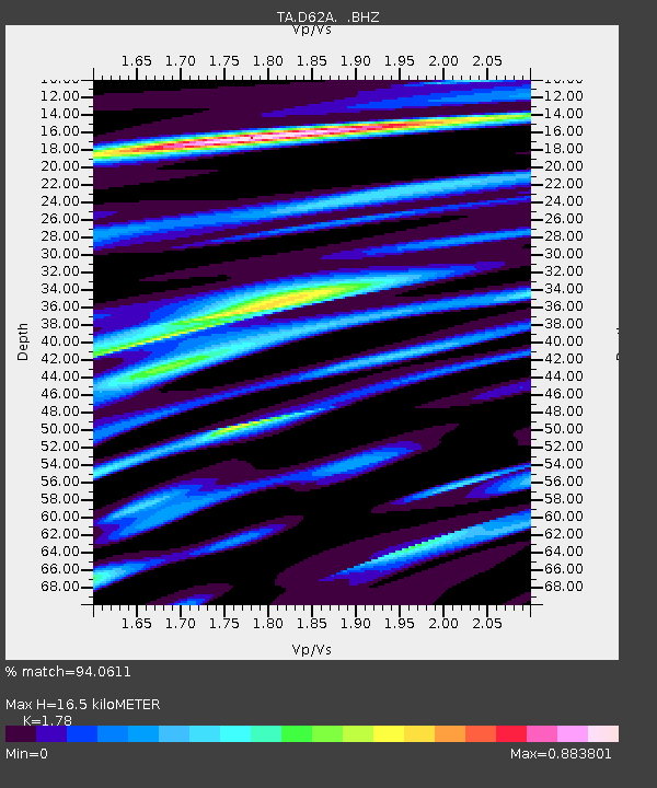
| Estimated Moho Depth: |
16.5 km |
| Estimated Crust Vp/Vs: |
1.78 |
| Assumed Crust Vp: |
6.419 km/s |
| Estimated Crust Vs: |
3.606 km/s |
| Estimated Crust Poisson's Ratio: |
0.27 |
|
| Radial Match: |
94.0611 % |
| Radial Bump: |
341 |
| Transverse Match: |
71.34717 % |
| Transverse Bump: |
400 |
| SOD ConfigId: |
626651 |
| Insert Time: |
2014-04-25 21:06:16.757 +0000 |
| GWidth: |
2.5 |
| Max Bumps: |
400 |
| Tol: |
0.001 |
|

Signal To Noise
| Channel | StoN | STA | LTA |
| TA:D62A: :BHZ:20140411T20:35:49.050012Z | 34.270924 | 7.525495E-6 | 2.1958833E-7 |
| TA:D62A: :BHN:20140411T20:35:49.050012Z | 9.978203 | 4.303069E-6 | 4.3124692E-7 |
| TA:D62A: :BHE:20140411T20:35:49.050012Z | 10.944881 | 2.1875474E-6 | 1.9986945E-7 |
| Arrivals |
| Ps | 2.2 SECOND |
| PpPs | 6.7 SECOND |
| PsPs/PpSs | 8.8 SECOND |


