You are here: Home > Network List > TA - USArray Transportable Network (new EarthScope stations) Stations List
> Station F48A Evansville, ON, CAN > Earthquake Result Viewer
F48A Evansville, ON, CAN - Earthquake Result Viewer
| Earthquake location: |
Near Coast Of Nicaragua |
| Earthquake latitude/longitude: |
11.6/-86.0 |
| Earthquake time(UTC): |
2014/04/11 (101) 20:29:13 GMT |
| Earthquake Depth: |
135 km |
| Earthquake Magnitude: |
6.6 MWW, 6.6 MWC, 6.6 MWB, 6.6 MI |
| Earthquake Catalog/Contributor: |
NEIC PDE/NEIC COMCAT |
|
| Network: |
TA USArray Transportable Network (new EarthScope stations) |
| Station: |
F48A Evansville, ON, CAN |
| Lat/Lon: |
45.83 N/82.62 W |
| Elevation: |
203 m |
|
| Distance: |
34.2 deg |
| Az: |
4.253 deg |
| Baz: |
185.965 deg |
| Ray Param: |
0.07739364 |
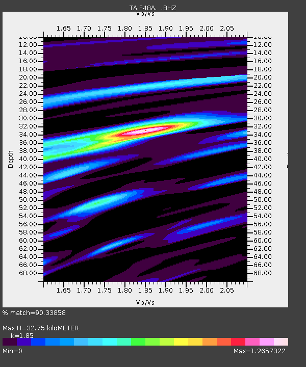
| Estimated Moho Depth: |
32.75 km |
| Estimated Crust Vp/Vs: |
1.85 |
| Assumed Crust Vp: |
6.483 km/s |
| Estimated Crust Vs: |
3.504 km/s |
| Estimated Crust Poisson's Ratio: |
0.29 |
|
| Radial Match: |
90.33858 % |
| Radial Bump: |
388 |
| Transverse Match: |
59.278564 % |
| Transverse Bump: |
400 |
| SOD ConfigId: |
626651 |
| Insert Time: |
2014-04-25 21:07:09.437 +0000 |
| GWidth: |
2.5 |
| Max Bumps: |
400 |
| Tol: |
0.001 |
|
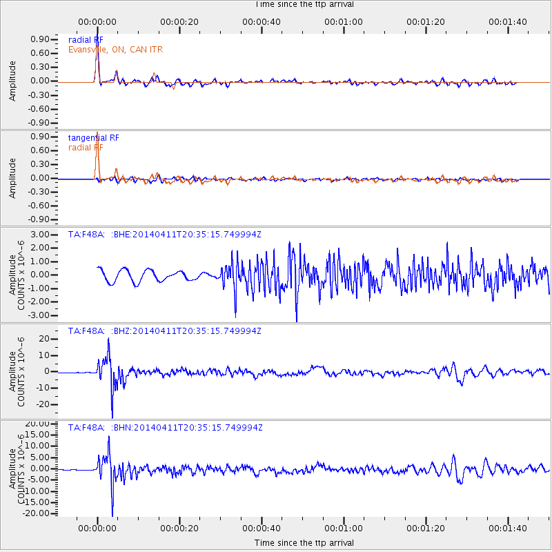
Signal To Noise
| Channel | StoN | STA | LTA |
| TA:F48A: :BHZ:20140411T20:35:15.749994Z | 37.86785 | 9.423479E-6 | 2.488517E-7 |
| TA:F48A: :BHN:20140411T20:35:15.749994Z | 44.524727 | 6.6933235E-6 | 1.5032825E-7 |
| TA:F48A: :BHE:20140411T20:35:15.749994Z | 2.2532725 | 9.2029654E-7 | 4.0842664E-7 |
| Arrivals |
| Ps | 4.6 SECOND |
| PpPs | 13 SECOND |
| PsPs/PpSs | 18 SECOND |


