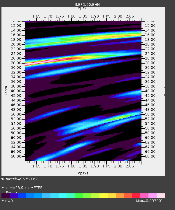
BFO Black Forest Observatory, Schiltach, Germany - Earthquake Result Viewer
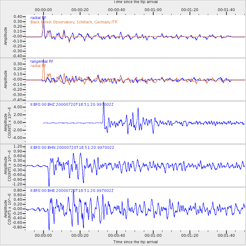
Earthquake location: Near East Coast Of Honshu, Japan
Earthquake latitude/longitude: 36.5/141.0
Earthquake time(UTC): 2000/07/20 (202) 18:39:18 GMT
Earthquake Depth: 47 km
Earthquake Magnitude: 6.1 MB, 5.4 MS, 6.1 ME, 6.0 MW
Earthquake Catalog/Contributor: WHDF/NEIC
Network: II Global Seismograph Network (GSN - IRIS/IDA)
Station: BFO Black Forest Observatory, Schiltach, Germany
Lat/Lon: 48.33 N/8.33 E
Elevation: 589 m
Distance: 85.6 deg
Az: 330.511 deg
Baz: 36.463 deg
Ray Param: 0.044579864
Estimated Moho Depth: 28.0 km
Estimated Crust Vp/Vs: 1.63
Assumed Crust Vp: 6.264 km/s
Estimated Crust Vs: 3.843 km/s
Estimated Crust Poisson's Ratio: 0.20
Radial Match: 95.52167 %
Radial Bump: 390
Transverse Match: 91.29723 %
Transverse Bump: 400
SOD ConfigId: 3744
Insert Time: 2010-03-01 20:46:27.624 +0000
GWidth: 2.5
Max Bumps: 400
Tol: 0.001

Signal To Noise

ChannelStoNSTALTA
II:BFO:00:BHN:20000720T18:51:20.997002Z16.9529344.007327E-72.3637954E-8
II:BFO:00:BHE:20000720T18:51:20.997002Z8.7904343.0161604E-73.431185E-8
II:BFO:00:BHZ:20000720T18:51:20.997002Z42.7797781.6019251E-63.744585E-8
Arrivals
Ps2.9 SECOND
PpPs11 SECOND
PsPs/PpSs14 SECOND