You are here: Home > Network List > TA - USArray Transportable Network (new EarthScope stations) Stations List
> Station F49A Sandfield, ON, CAN > Earthquake Result Viewer
F49A Sandfield, ON, CAN - Earthquake Result Viewer
| Earthquake location: |
Near Coast Of Nicaragua |
| Earthquake latitude/longitude: |
11.6/-86.0 |
| Earthquake time(UTC): |
2014/04/11 (101) 20:29:13 GMT |
| Earthquake Depth: |
135 km |
| Earthquake Magnitude: |
6.6 MWW, 6.6 MWC, 6.6 MWB, 6.6 MI |
| Earthquake Catalog/Contributor: |
NEIC PDE/NEIC COMCAT |
|
| Network: |
TA USArray Transportable Network (new EarthScope stations) |
| Station: |
F49A Sandfield, ON, CAN |
| Lat/Lon: |
45.76 N/82.04 W |
| Elevation: |
230 m |
|
| Distance: |
34.2 deg |
| Az: |
4.978 deg |
| Baz: |
186.976 deg |
| Ray Param: |
0.077403516 |
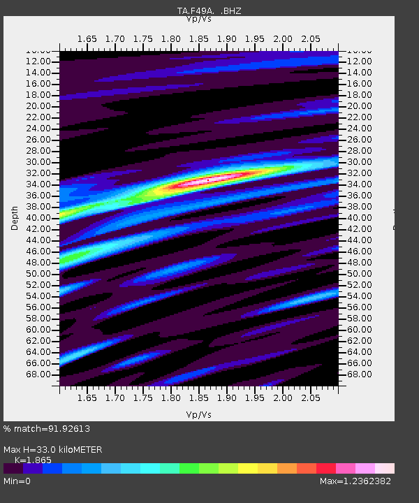
| Estimated Moho Depth: |
33.0 km |
| Estimated Crust Vp/Vs: |
1.87 |
| Assumed Crust Vp: |
6.483 km/s |
| Estimated Crust Vs: |
3.476 km/s |
| Estimated Crust Poisson's Ratio: |
0.30 |
|
| Radial Match: |
91.92613 % |
| Radial Bump: |
362 |
| Transverse Match: |
77.03691 % |
| Transverse Bump: |
400 |
| SOD ConfigId: |
626651 |
| Insert Time: |
2014-04-25 21:07:10.002 +0000 |
| GWidth: |
2.5 |
| Max Bumps: |
400 |
| Tol: |
0.001 |
|
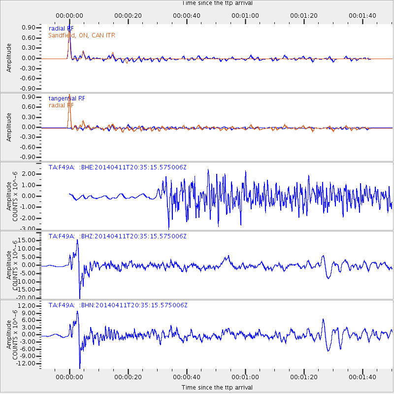
Signal To Noise
| Channel | StoN | STA | LTA |
| TA:F49A: :BHZ:20140411T20:35:15.575006Z | 37.658806 | 8.445579E-6 | 2.242657E-7 |
| TA:F49A: :BHN:20140411T20:35:15.575006Z | 21.867899 | 5.6097483E-6 | 2.565289E-7 |
| TA:F49A: :BHE:20140411T20:35:15.575006Z | 7.0917726 | 9.488884E-7 | 1.338013E-7 |
| Arrivals |
| Ps | 4.7 SECOND |
| PpPs | 14 SECOND |
| PsPs/PpSs | 18 SECOND |


