You are here: Home > Network List > TA - USArray Transportable Network (new EarthScope stations) Stations List
> Station G62A West of Eustis, ME, USA > Earthquake Result Viewer
G62A West of Eustis, ME, USA - Earthquake Result Viewer
| Earthquake location: |
Near Coast Of Nicaragua |
| Earthquake latitude/longitude: |
11.6/-86.0 |
| Earthquake time(UTC): |
2014/04/11 (101) 20:29:13 GMT |
| Earthquake Depth: |
135 km |
| Earthquake Magnitude: |
6.6 MWW, 6.6 MWC, 6.6 MWB, 6.6 MI |
| Earthquake Catalog/Contributor: |
NEIC PDE/NEIC COMCAT |
|
| Network: |
TA USArray Transportable Network (new EarthScope stations) |
| Station: |
G62A West of Eustis, ME, USA |
| Lat/Lon: |
45.22 N/70.53 W |
| Elevation: |
426 m |
|
| Distance: |
36.0 deg |
| Az: |
18.734 deg |
| Baz: |
206.44 deg |
| Ray Param: |
0.07643265 |
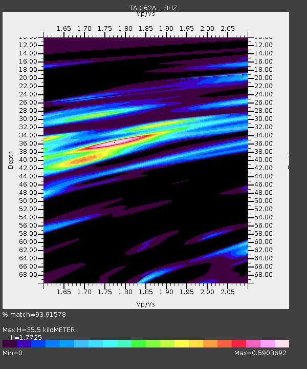
| Estimated Moho Depth: |
35.5 km |
| Estimated Crust Vp/Vs: |
1.77 |
| Assumed Crust Vp: |
6.419 km/s |
| Estimated Crust Vs: |
3.622 km/s |
| Estimated Crust Poisson's Ratio: |
0.27 |
|
| Radial Match: |
93.91578 % |
| Radial Bump: |
275 |
| Transverse Match: |
88.43318 % |
| Transverse Bump: |
400 |
| SOD ConfigId: |
626651 |
| Insert Time: |
2014-04-25 21:08:03.872 +0000 |
| GWidth: |
2.5 |
| Max Bumps: |
400 |
| Tol: |
0.001 |
|

Signal To Noise
| Channel | StoN | STA | LTA |
| TA:G62A: :BHZ:20140411T20:35:31.124994Z | 30.765678 | 6.520691E-6 | 2.1194693E-7 |
| TA:G62A: :BHN:20140411T20:35:31.124994Z | 7.4049625 | 2.9299872E-6 | 3.9567888E-7 |
| TA:G62A: :BHE:20140411T20:35:31.124994Z | 8.405382 | 2.2030595E-6 | 2.6210105E-7 |
| Arrivals |
| Ps | 4.6 SECOND |
| PpPs | 14 SECOND |
| PsPs/PpSs | 19 SECOND |


