You are here: Home > Network List > TA - USArray Transportable Network (new EarthScope stations) Stations List
> Station H45A Beulah, MI, USA > Earthquake Result Viewer
H45A Beulah, MI, USA - Earthquake Result Viewer
| Earthquake location: |
Near Coast Of Nicaragua |
| Earthquake latitude/longitude: |
11.6/-86.0 |
| Earthquake time(UTC): |
2014/04/11 (101) 20:29:13 GMT |
| Earthquake Depth: |
135 km |
| Earthquake Magnitude: |
6.6 MWW, 6.6 MWC, 6.6 MWB, 6.6 MI |
| Earthquake Catalog/Contributor: |
NEIC PDE/NEIC COMCAT |
|
| Network: |
TA USArray Transportable Network (new EarthScope stations) |
| Station: |
H45A Beulah, MI, USA |
| Lat/Lon: |
44.62 N/86.04 W |
| Elevation: |
242 m |
|
| Distance: |
32.9 deg |
| Az: |
359.995 deg |
| Baz: |
179.993 deg |
| Ray Param: |
0.07804372 |
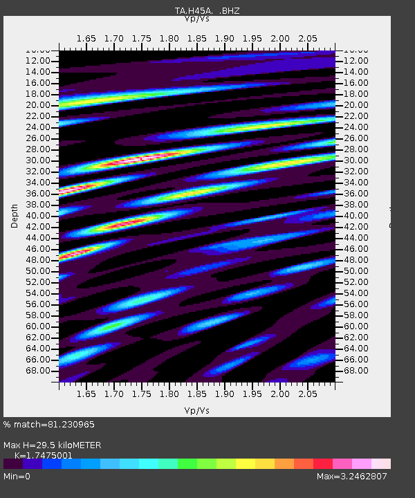
| Estimated Moho Depth: |
29.5 km |
| Estimated Crust Vp/Vs: |
1.75 |
| Assumed Crust Vp: |
6.53 km/s |
| Estimated Crust Vs: |
3.737 km/s |
| Estimated Crust Poisson's Ratio: |
0.26 |
|
| Radial Match: |
81.230965 % |
| Radial Bump: |
400 |
| Transverse Match: |
73.2738 % |
| Transverse Bump: |
400 |
| SOD ConfigId: |
626651 |
| Insert Time: |
2014-04-25 21:08:17.303 +0000 |
| GWidth: |
2.5 |
| Max Bumps: |
400 |
| Tol: |
0.001 |
|
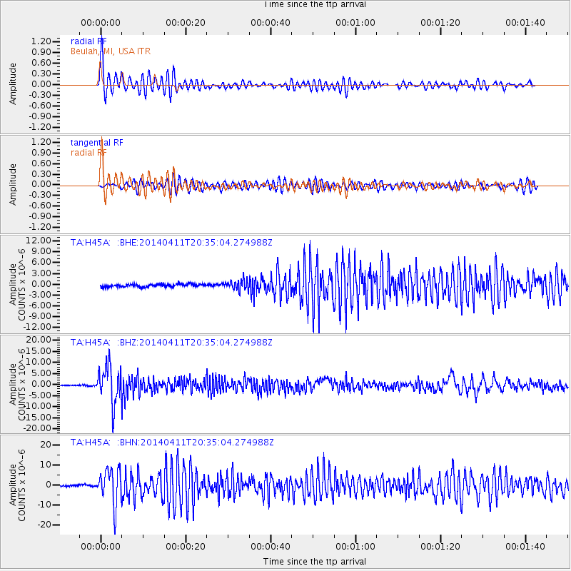
Signal To Noise
| Channel | StoN | STA | LTA |
| TA:H45A: :BHZ:20140411T20:35:04.274988Z | 39.94859 | 8.6491555E-6 | 2.1650716E-7 |
| TA:H45A: :BHN:20140411T20:35:04.274988Z | 18.382414 | 8.966265E-6 | 4.877632E-7 |
| TA:H45A: :BHE:20140411T20:35:04.274988Z | 3.3237462 | 1.2807029E-6 | 3.853191E-7 |
| Arrivals |
| Ps | 3.7 SECOND |
| PpPs | 11 SECOND |
| PsPs/PpSs | 15 SECOND |


