You are here: Home > Network List > TA - USArray Transportable Network (new EarthScope stations) Stations List
> Station H47A Mio, MI, USA > Earthquake Result Viewer
H47A Mio, MI, USA - Earthquake Result Viewer
| Earthquake location: |
Near Coast Of Nicaragua |
| Earthquake latitude/longitude: |
11.6/-86.0 |
| Earthquake time(UTC): |
2014/04/11 (101) 20:29:13 GMT |
| Earthquake Depth: |
135 km |
| Earthquake Magnitude: |
6.6 MWW, 6.6 MWC, 6.6 MWB, 6.6 MI |
| Earthquake Catalog/Contributor: |
NEIC PDE/NEIC COMCAT |
|
| Network: |
TA USArray Transportable Network (new EarthScope stations) |
| Station: |
H47A Mio, MI, USA |
| Lat/Lon: |
44.60 N/84.21 W |
| Elevation: |
356 m |
|
| Distance: |
32.9 deg |
| Az: |
2.41 deg |
| Baz: |
183.307 deg |
| Ray Param: |
0.07803733 |
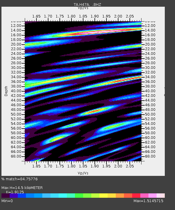
| Estimated Moho Depth: |
14.5 km |
| Estimated Crust Vp/Vs: |
1.91 |
| Assumed Crust Vp: |
6.483 km/s |
| Estimated Crust Vs: |
3.39 km/s |
| Estimated Crust Poisson's Ratio: |
0.31 |
|
| Radial Match: |
84.75776 % |
| Radial Bump: |
400 |
| Transverse Match: |
71.44759 % |
| Transverse Bump: |
400 |
| SOD ConfigId: |
626651 |
| Insert Time: |
2014-04-25 21:08:21.780 +0000 |
| GWidth: |
2.5 |
| Max Bumps: |
400 |
| Tol: |
0.001 |
|
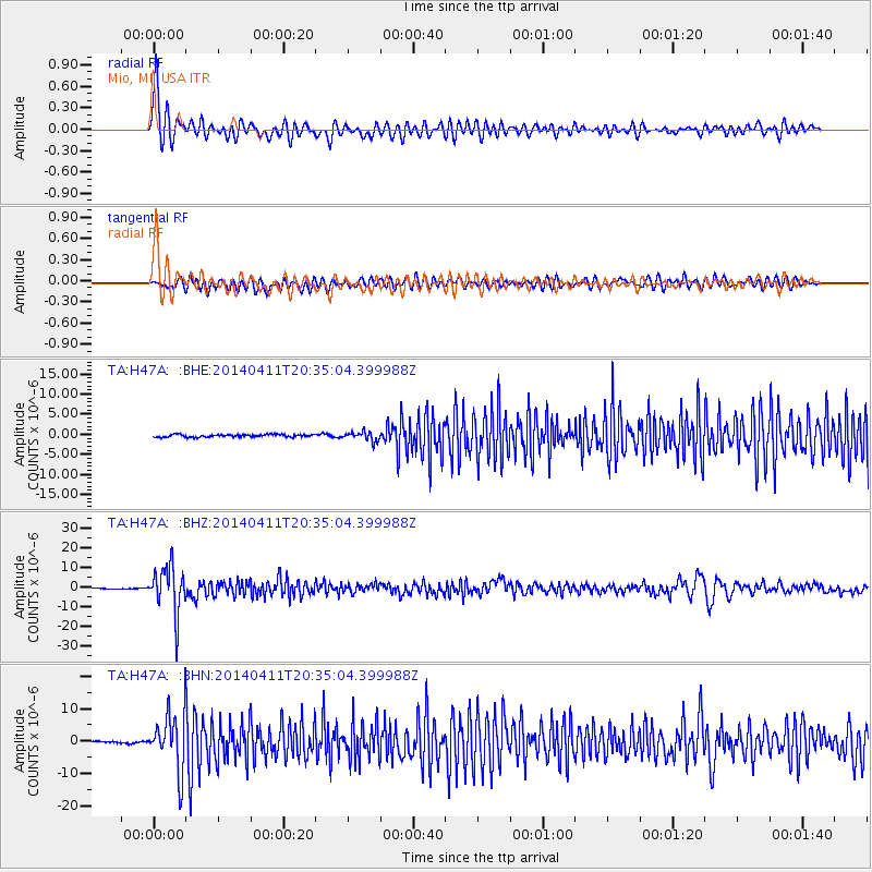
Signal To Noise
| Channel | StoN | STA | LTA |
| TA:H47A: :BHZ:20140411T20:35:04.399988Z | 55.235683 | 1.2043148E-5 | 2.1803203E-7 |
| TA:H47A: :BHN:20140411T20:35:04.399988Z | 27.393692 | 8.8140905E-6 | 3.217562E-7 |
| TA:H47A: :BHE:20140411T20:35:04.399988Z | 3.7591324 | 1.1680607E-6 | 3.1072616E-7 |
| Arrivals |
| Ps | 2.2 SECOND |
| PpPs | 6.1 SECOND |
| PsPs/PpSs | 8.3 SECOND |


