You are here: Home > Network List > TA - USArray Transportable Network (new EarthScope stations) Stations List
> Station I46A Reed City, MI, USA > Earthquake Result Viewer
I46A Reed City, MI, USA - Earthquake Result Viewer
| Earthquake location: |
Near Coast Of Nicaragua |
| Earthquake latitude/longitude: |
11.6/-86.0 |
| Earthquake time(UTC): |
2014/04/11 (101) 20:29:13 GMT |
| Earthquake Depth: |
135 km |
| Earthquake Magnitude: |
6.6 MWW, 6.6 MWC, 6.6 MWB, 6.6 MI |
| Earthquake Catalog/Contributor: |
NEIC PDE/NEIC COMCAT |
|
| Network: |
TA USArray Transportable Network (new EarthScope stations) |
| Station: |
I46A Reed City, MI, USA |
| Lat/Lon: |
43.94 N/85.45 W |
| Elevation: |
359 m |
|
| Distance: |
32.2 deg |
| Az: |
0.803 deg |
| Baz: |
181.089 deg |
| Ray Param: |
0.07835356 |
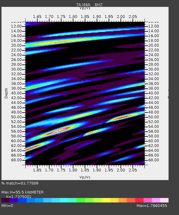
| Estimated Moho Depth: |
55.5 km |
| Estimated Crust Vp/Vs: |
1.74 |
| Assumed Crust Vp: |
6.483 km/s |
| Estimated Crust Vs: |
3.731 km/s |
| Estimated Crust Poisson's Ratio: |
0.25 |
|
| Radial Match: |
83.77889 % |
| Radial Bump: |
400 |
| Transverse Match: |
75.454475 % |
| Transverse Bump: |
400 |
| SOD ConfigId: |
626651 |
| Insert Time: |
2014-04-25 21:09:11.476 +0000 |
| GWidth: |
2.5 |
| Max Bumps: |
400 |
| Tol: |
0.001 |
|
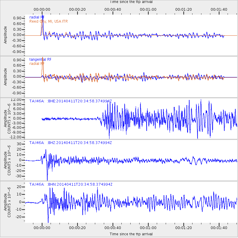
Signal To Noise
| Channel | StoN | STA | LTA |
| TA:I46A: :BHZ:20140411T20:34:58.374994Z | 47.48567 | 1.1446904E-5 | 2.4106018E-7 |
| TA:I46A: :BHN:20140411T20:34:58.374994Z | 24.046162 | 9.003749E-6 | 3.74436E-7 |
| TA:I46A: :BHE:20140411T20:34:58.374994Z | 4.4821773 | 1.3720432E-6 | 3.0611088E-7 |
| Arrivals |
| Ps | 6.9 SECOND |
| PpPs | 22 SECOND |
| PsPs/PpSs | 28 SECOND |


