You are here: Home > Network List > TA - USArray Transportable Network (new EarthScope stations) Stations List
> Station I48A Sherman Twp, MI, USA > Earthquake Result Viewer
I48A Sherman Twp, MI, USA - Earthquake Result Viewer

| Earthquake location: |
Near Coast Of Nicaragua |
| Earthquake latitude/longitude: |
11.6/-86.0 |
| Earthquake time(UTC): |
2014/04/11 (101) 20:29:13 GMT |
| Earthquake Depth: |
135 km |
| Earthquake Magnitude: |
6.6 MWW, 6.6 MWC, 6.6 MWB, 6.6 MI |
| Earthquake Catalog/Contributor: |
NEIC PDE/NEIC COMCAT |
|
| Network: |
TA USArray Transportable Network (new EarthScope stations) |
| Station: |
I48A Sherman Twp, MI, USA |
| Lat/Lon: |
44.19 N/83.70 W |
| Elevation: |
192 m |
|
| Distance: |
32.5 deg |
| Az: |
3.127 deg |
| Baz: |
184.261 deg |
| Ray Param: |
0.07821416 |
| Estimated Moho Depth: |
37.25 km |
| Estimated Crust Vp/Vs: |
1.80 |
| Assumed Crust Vp: |
6.483 km/s |
| Estimated Crust Vs: |
3.606 km/s |
| Estimated Crust Poisson's Ratio: |
0.28 |
|
| Radial Match: |
90.20139 % |
| Radial Bump: |
400 |
| Transverse Match: |
76.686386 % |
| Transverse Bump: |
400 |
| SOD ConfigId: |
626651 |
| Insert Time: |
2014-04-25 21:09:15.908 +0000 |
| GWidth: |
2.5 |
| Max Bumps: |
400 |
| Tol: |
0.001 |
|
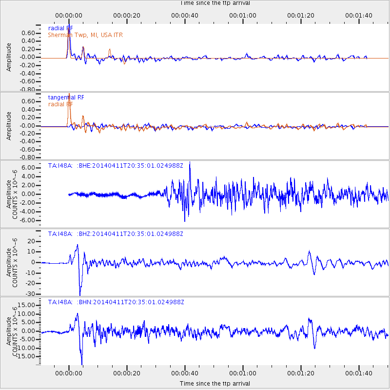
Signal To Noise
| Channel | StoN | STA | LTA |
| TA:I48A: :BHZ:20140411T20:35:01.024988Z | 25.9508 | 1.2292784E-5 | 4.736958E-7 |
| TA:I48A: :BHN:20140411T20:35:01.024988Z | 17.381973 | 7.181763E-6 | 4.1317307E-7 |
| TA:I48A: :BHE:20140411T20:35:01.024988Z | 3.1604116 | 9.1562146E-7 | 2.897159E-7 |
| Arrivals |
| Ps | 5.0 SECOND |
| PpPs | 15 SECOND |
| PsPs/PpSs | 20 SECOND |


