You are here: Home > Network List > TA - USArray Transportable Network (new EarthScope stations) Stations List
> Station J54A Appleton, NY, USA > Earthquake Result Viewer
J54A Appleton, NY, USA - Earthquake Result Viewer

| Earthquake location: |
Near Coast Of Nicaragua |
| Earthquake latitude/longitude: |
11.6/-86.0 |
| Earthquake time(UTC): |
2014/04/11 (101) 20:29:13 GMT |
| Earthquake Depth: |
135 km |
| Earthquake Magnitude: |
6.6 MWW, 6.6 MWC, 6.6 MWB, 6.6 MI |
| Earthquake Catalog/Contributor: |
NEIC PDE/NEIC COMCAT |
|
| Network: |
TA USArray Transportable Network (new EarthScope stations) |
| Station: |
J54A Appleton, NY, USA |
| Lat/Lon: |
43.27 N/78.64 W |
| Elevation: |
112 m |
|
| Distance: |
32.2 deg |
| Az: |
10.166 deg |
| Baz: |
193.697 deg |
| Ray Param: |
0.07836536 |
| Estimated Moho Depth: |
43.25 km |
| Estimated Crust Vp/Vs: |
1.73 |
| Assumed Crust Vp: |
6.419 km/s |
| Estimated Crust Vs: |
3.716 km/s |
| Estimated Crust Poisson's Ratio: |
0.25 |
|
| Radial Match: |
93.29114 % |
| Radial Bump: |
276 |
| Transverse Match: |
72.087326 % |
| Transverse Bump: |
400 |
| SOD ConfigId: |
626651 |
| Insert Time: |
2014-04-25 21:10:04.587 +0000 |
| GWidth: |
2.5 |
| Max Bumps: |
400 |
| Tol: |
0.001 |
|
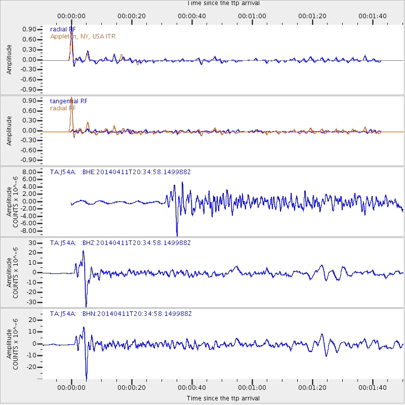
Signal To Noise
| Channel | StoN | STA | LTA |
| TA:J54A: :BHZ:20140411T20:34:58.149988Z | 37.15298 | 1.0625062E-5 | 2.859814E-7 |
| TA:J54A: :BHN:20140411T20:34:58.149988Z | 21.922615 | 7.1857053E-6 | 3.2777595E-7 |
| TA:J54A: :BHE:20140411T20:34:58.149988Z | 6.132398 | 1.8129006E-6 | 2.9562668E-7 |
| Arrivals |
| Ps | 5.3 SECOND |
| PpPs | 17 SECOND |
| PsPs/PpSs | 22 SECOND |


