You are here: Home > Network List > TA - USArray Transportable Network (new EarthScope stations) Stations List
> Station J57A Williamstown, NY, USA > Earthquake Result Viewer
J57A Williamstown, NY, USA - Earthquake Result Viewer
| Earthquake location: |
Near Coast Of Nicaragua |
| Earthquake latitude/longitude: |
11.6/-86.0 |
| Earthquake time(UTC): |
2014/04/11 (101) 20:29:13 GMT |
| Earthquake Depth: |
135 km |
| Earthquake Magnitude: |
6.6 MWW, 6.6 MWC, 6.6 MWB, 6.6 MI |
| Earthquake Catalog/Contributor: |
NEIC PDE/NEIC COMCAT |
|
| Network: |
TA USArray Transportable Network (new EarthScope stations) |
| Station: |
J57A Williamstown, NY, USA |
| Lat/Lon: |
43.41 N/76.00 W |
| Elevation: |
191 m |
|
| Distance: |
32.9 deg |
| Az: |
13.54 deg |
| Baz: |
198.349 deg |
| Ray Param: |
0.078061685 |
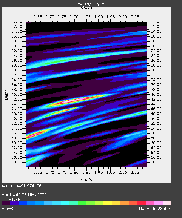
| Estimated Moho Depth: |
42.25 km |
| Estimated Crust Vp/Vs: |
1.79 |
| Assumed Crust Vp: |
6.419 km/s |
| Estimated Crust Vs: |
3.586 km/s |
| Estimated Crust Poisson's Ratio: |
0.27 |
|
| Radial Match: |
91.974106 % |
| Radial Bump: |
276 |
| Transverse Match: |
70.03148 % |
| Transverse Bump: |
400 |
| SOD ConfigId: |
626651 |
| Insert Time: |
2014-04-25 21:10:11.703 +0000 |
| GWidth: |
2.5 |
| Max Bumps: |
400 |
| Tol: |
0.001 |
|
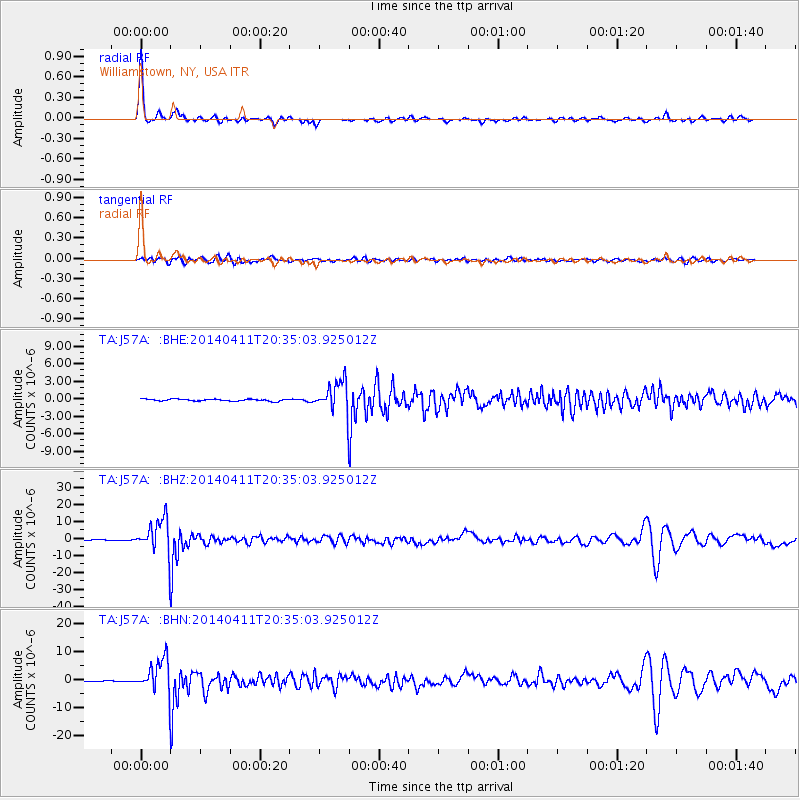
Signal To Noise
| Channel | StoN | STA | LTA |
| TA:J57A: :BHZ:20140411T20:35:03.925012Z | 32.379086 | 9.937203E-6 | 3.069019E-7 |
| TA:J57A: :BHN:20140411T20:35:03.925012Z | 30.142025 | 5.8143282E-6 | 1.9289772E-7 |
| TA:J57A: :BHE:20140411T20:35:03.925012Z | 14.966019 | 2.5649138E-6 | 1.7138251E-7 |
| Arrivals |
| Ps | 5.6 SECOND |
| PpPs | 17 SECOND |
| PsPs/PpSs | 23 SECOND |


