You are here: Home > Network List > TA - USArray Transportable Network (new EarthScope stations) Stations List
> Station J61A Chester, VT, USA > Earthquake Result Viewer
J61A Chester, VT, USA - Earthquake Result Viewer
| Earthquake location: |
Near Coast Of Nicaragua |
| Earthquake latitude/longitude: |
11.6/-86.0 |
| Earthquake time(UTC): |
2014/04/11 (101) 20:29:13 GMT |
| Earthquake Depth: |
135 km |
| Earthquake Magnitude: |
6.6 MWW, 6.6 MWC, 6.6 MWB, 6.6 MI |
| Earthquake Catalog/Contributor: |
NEIC PDE/NEIC COMCAT |
|
| Network: |
TA USArray Transportable Network (new EarthScope stations) |
| Station: |
J61A Chester, VT, USA |
| Lat/Lon: |
43.35 N/72.55 W |
| Elevation: |
253 m |
|
| Distance: |
33.7 deg |
| Az: |
17.842 deg |
| Baz: |
204.302 deg |
| Ray Param: |
0.07765709 |
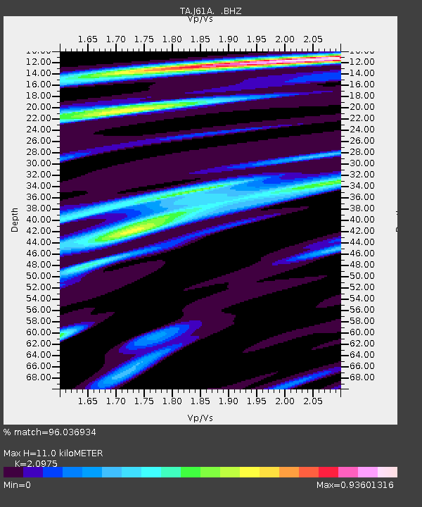
| Estimated Moho Depth: |
11.0 km |
| Estimated Crust Vp/Vs: |
2.10 |
| Assumed Crust Vp: |
6.419 km/s |
| Estimated Crust Vs: |
3.06 km/s |
| Estimated Crust Poisson's Ratio: |
0.35 |
|
| Radial Match: |
96.036934 % |
| Radial Bump: |
298 |
| Transverse Match: |
89.01292 % |
| Transverse Bump: |
400 |
| SOD ConfigId: |
626651 |
| Insert Time: |
2014-04-25 21:10:20.547 +0000 |
| GWidth: |
2.5 |
| Max Bumps: |
400 |
| Tol: |
0.001 |
|

Signal To Noise
| Channel | StoN | STA | LTA |
| TA:J61A: :BHZ:20140411T20:35:11.325006Z | 21.988718 | 5.66768E-6 | 2.57754E-7 |
| TA:J61A: :BHN:20140411T20:35:11.325006Z | 15.232707 | 3.568275E-6 | 2.3425088E-7 |
| TA:J61A: :BHE:20140411T20:35:11.325006Z | 6.7715006 | 1.4311696E-6 | 2.1135192E-7 |
| Arrivals |
| Ps | 2.0 SECOND |
| PpPs | 5.0 SECOND |
| PsPs/PpSs | 7.0 SECOND |


