You are here: Home > Network List > TA - USArray Transportable Network (new EarthScope stations) Stations List
> Station K46A Dorr, MI, USA > Earthquake Result Viewer
K46A Dorr, MI, USA - Earthquake Result Viewer
| Earthquake location: |
Near Coast Of Nicaragua |
| Earthquake latitude/longitude: |
11.6/-86.0 |
| Earthquake time(UTC): |
2014/04/11 (101) 20:29:13 GMT |
| Earthquake Depth: |
135 km |
| Earthquake Magnitude: |
6.6 MWW, 6.6 MWC, 6.6 MWB, 6.6 MI |
| Earthquake Catalog/Contributor: |
NEIC PDE/NEIC COMCAT |
|
| Network: |
TA USArray Transportable Network (new EarthScope stations) |
| Station: |
K46A Dorr, MI, USA |
| Lat/Lon: |
42.69 N/85.78 W |
| Elevation: |
213 m |
|
| Distance: |
31.0 deg |
| Az: |
0.368 deg |
| Baz: |
180.488 deg |
| Ray Param: |
0.07889151 |
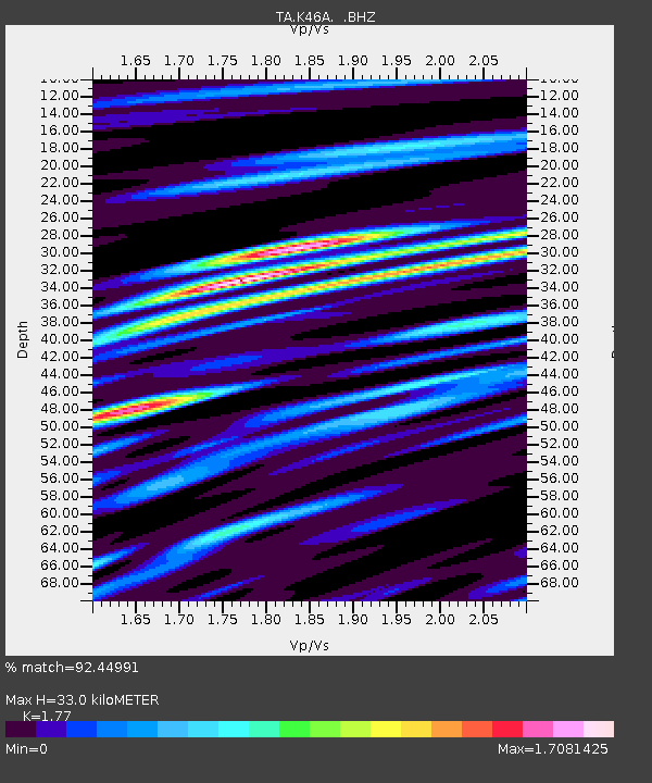
| Estimated Moho Depth: |
33.0 km |
| Estimated Crust Vp/Vs: |
1.77 |
| Assumed Crust Vp: |
6.483 km/s |
| Estimated Crust Vs: |
3.662 km/s |
| Estimated Crust Poisson's Ratio: |
0.27 |
|
| Radial Match: |
92.44991 % |
| Radial Bump: |
400 |
| Transverse Match: |
77.4782 % |
| Transverse Bump: |
400 |
| SOD ConfigId: |
626651 |
| Insert Time: |
2014-04-25 21:10:34.941 +0000 |
| GWidth: |
2.5 |
| Max Bumps: |
400 |
| Tol: |
0.001 |
|

Signal To Noise
| Channel | StoN | STA | LTA |
| TA:K46A: :BHZ:20140411T20:34:47.399988Z | 49.34961 | 1.7397817E-5 | 3.5254214E-7 |
| TA:K46A: :BHN:20140411T20:34:47.399988Z | 57.3792 | 1.2447206E-5 | 2.1692888E-7 |
| TA:K46A: :BHE:20140411T20:34:47.399988Z | 7.6453824 | 2.3178904E-6 | 3.0317523E-7 |
| Arrivals |
| Ps | 4.3 SECOND |
| PpPs | 13 SECOND |
| PsPs/PpSs | 17 SECOND |


