You are here: Home > Network List > TA - USArray Transportable Network (new EarthScope stations) Stations List
> Station J01E Myrtle Point, OR, USA > Earthquake Result Viewer
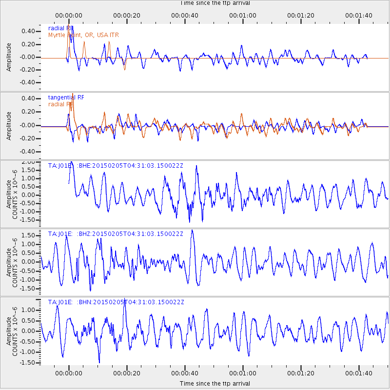
J01E Myrtle Point, OR, USA - Earthquake Result Viewer
*The percent match for this event was below the threshold and hence no stack was calculated.
| Earthquake location: |
Venezuela |
| Earthquake latitude/longitude: |
8.3/-72.1 |
| Earthquake time(UTC): |
2015/02/05 (036) 04:21:50 GMT |
| Earthquake Depth: |
22 km |
| Earthquake Magnitude: |
5.3 MW |
| Earthquake Catalog/Contributor: |
ISC/ISC |
|
| Network: |
TA USArray Transportable Network (new EarthScope stations) |
| Station: |
J01E Myrtle Point, OR, USA |
| Lat/Lon: |
43.16 N/123.93 W |
| Elevation: |
128 m |
|
| Distance: |
57.0 deg |
| Az: |
316.647 deg |
| Baz: |
111.806 deg |
| Ray Param: |
$rayparam |
*The percent match for this event was below the threshold and hence was not used in the summary stack. |
|
| Radial Match: |
54.166187 % |
| Radial Bump: |
400 |
| Transverse Match: |
50.168324 % |
| Transverse Bump: |
400 |
| SOD ConfigId: |
7019011 |
| Insert Time: |
2019-04-16 16:22:50.613 +0000 |
| GWidth: |
2.5 |
| Max Bumps: |
400 |
| Tol: |
0.001 |
|
Signal To Noise
| Channel | StoN | STA | LTA |
| TA:J01E: :BHZ:20150205T04:31:03.150022Z | 1.4641694 | 8.6378594E-7 | 5.899494E-7 |
| TA:J01E: :BHN:20150205T04:31:03.150022Z | 0.9940456 | 4.0721937E-7 | 4.0965867E-7 |
| TA:J01E: :BHE:20150205T04:31:03.150022Z | 1.0654693 | 7.113578E-7 | 6.676474E-7 |
| Arrivals |
| Ps | |
| PpPs | |
| PsPs/PpSs | |


