You are here: Home > Network List > TA - USArray Transportable Network (new EarthScope stations) Stations List
> Station L44A Lake County Forest Preserve, Grayslake, IL, USA > Earthquake Result Viewer
L44A Lake County Forest Preserve, Grayslake, IL, USA - Earthquake Result Viewer
| Earthquake location: |
Near Coast Of Nicaragua |
| Earthquake latitude/longitude: |
11.6/-86.0 |
| Earthquake time(UTC): |
2014/04/11 (101) 20:29:13 GMT |
| Earthquake Depth: |
135 km |
| Earthquake Magnitude: |
6.6 MWW, 6.6 MWC, 6.6 MWB, 6.6 MI |
| Earthquake Catalog/Contributor: |
NEIC PDE/NEIC COMCAT |
|
| Network: |
TA USArray Transportable Network (new EarthScope stations) |
| Station: |
L44A Lake County Forest Preserve, Grayslake, IL, USA |
| Lat/Lon: |
42.18 N/87.91 W |
| Elevation: |
202 m |
|
| Distance: |
30.5 deg |
| Az: |
357.259 deg |
| Baz: |
176.386 deg |
| Ray Param: |
0.07907597 |
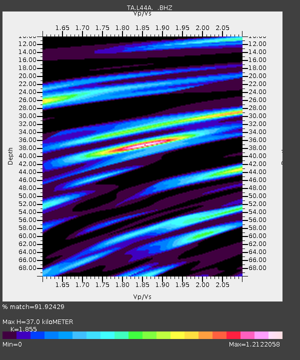
| Estimated Moho Depth: |
37.0 km |
| Estimated Crust Vp/Vs: |
1.86 |
| Assumed Crust Vp: |
6.483 km/s |
| Estimated Crust Vs: |
3.495 km/s |
| Estimated Crust Poisson's Ratio: |
0.30 |
|
| Radial Match: |
91.92429 % |
| Radial Bump: |
335 |
| Transverse Match: |
71.56801 % |
| Transverse Bump: |
400 |
| SOD ConfigId: |
626651 |
| Insert Time: |
2014-04-25 21:11:22.249 +0000 |
| GWidth: |
2.5 |
| Max Bumps: |
400 |
| Tol: |
0.001 |
|
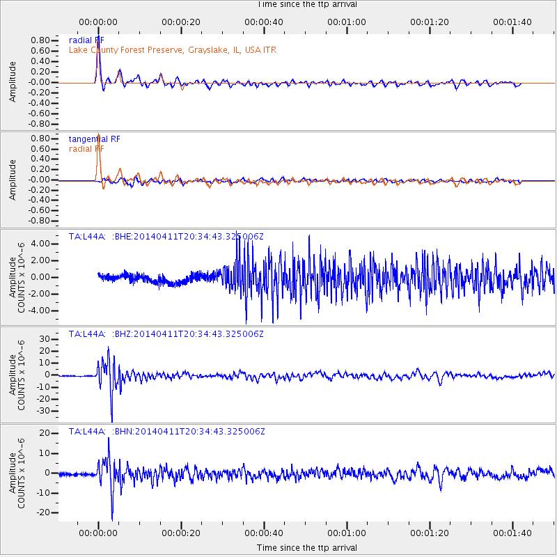
Signal To Noise
| Channel | StoN | STA | LTA |
| TA:L44A: :BHZ:20140411T20:34:43.325006Z | 52.52195 | 1.2923456E-5 | 2.460582E-7 |
| TA:L44A: :BHN:20140411T20:34:43.325006Z | 17.186228 | 7.884422E-6 | 4.5876402E-7 |
| TA:L44A: :BHE:20140411T20:34:43.325006Z | 3.7050507 | 1.6799625E-6 | 4.5342495E-7 |
| Arrivals |
| Ps | 5.3 SECOND |
| PpPs | 15 SECOND |
| PsPs/PpSs | 20 SECOND |


