You are here: Home > Network List > TA - USArray Transportable Network (new EarthScope stations) Stations List
> Station L57A Andrews Acres Farm, Gillet, PA, USA > Earthquake Result Viewer
L57A Andrews Acres Farm, Gillet, PA, USA - Earthquake Result Viewer

| Earthquake location: |
Near Coast Of Nicaragua |
| Earthquake latitude/longitude: |
11.6/-86.0 |
| Earthquake time(UTC): |
2014/04/11 (101) 20:29:13 GMT |
| Earthquake Depth: |
135 km |
| Earthquake Magnitude: |
6.6 MWW, 6.6 MWC, 6.6 MWB, 6.6 MI |
| Earthquake Catalog/Contributor: |
NEIC PDE/NEIC COMCAT |
|
| Network: |
TA USArray Transportable Network (new EarthScope stations) |
| Station: |
L57A Andrews Acres Farm, Gillet, PA, USA |
| Lat/Lon: |
42.00 N/76.85 W |
| Elevation: |
546 m |
|
| Distance: |
31.3 deg |
| Az: |
13.231 deg |
| Baz: |
197.511 deg |
| Ray Param: |
0.07873861 |
| Estimated Moho Depth: |
41.75 km |
| Estimated Crust Vp/Vs: |
1.82 |
| Assumed Crust Vp: |
6.476 km/s |
| Estimated Crust Vs: |
3.558 km/s |
| Estimated Crust Poisson's Ratio: |
0.28 |
|
| Radial Match: |
86.42074 % |
| Radial Bump: |
400 |
| Transverse Match: |
78.999756 % |
| Transverse Bump: |
400 |
| SOD ConfigId: |
626651 |
| Insert Time: |
2014-04-25 21:11:41.478 +0000 |
| GWidth: |
2.5 |
| Max Bumps: |
400 |
| Tol: |
0.001 |
|
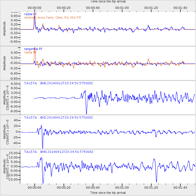
Signal To Noise
| Channel | StoN | STA | LTA |
| TA:L57A: :BHZ:20140411T20:34:50.575006Z | 29.955236 | 9.686003E-6 | 3.2334924E-7 |
| TA:L57A: :BHN:20140411T20:34:50.575006Z | 19.646038 | 4.573414E-6 | 2.3279067E-7 |
| TA:L57A: :BHE:20140411T20:34:50.575006Z | 8.512187 | 2.1286178E-6 | 2.500671E-7 |
| Arrivals |
| Ps | 5.7 SECOND |
| PpPs | 17 SECOND |
| PsPs/PpSs | 23 SECOND |


