You are here: Home > Network List > TA - USArray Transportable Network (new EarthScope stations) Stations List
> Station O48A Farmland, IN, USA > Earthquake Result Viewer
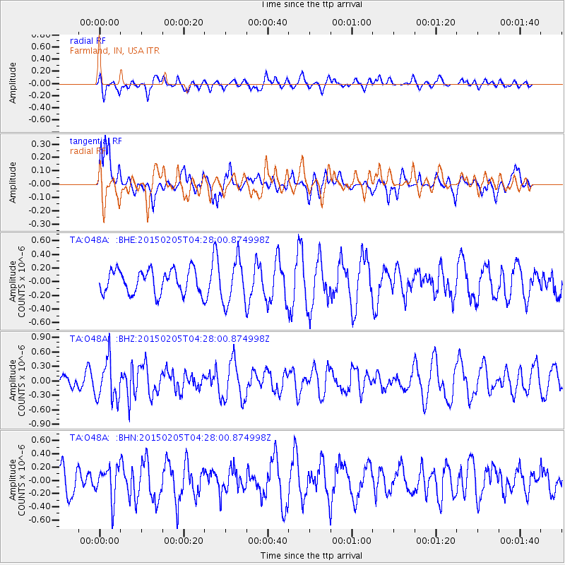
O48A Farmland, IN, USA - Earthquake Result Viewer
*The percent match for this event was below the threshold and hence no stack was calculated.
| Earthquake location: |
Venezuela |
| Earthquake latitude/longitude: |
8.3/-72.1 |
| Earthquake time(UTC): |
2015/02/05 (036) 04:21:50 GMT |
| Earthquake Depth: |
22 km |
| Earthquake Magnitude: |
5.3 MW |
| Earthquake Catalog/Contributor: |
ISC/ISC |
|
| Network: |
TA USArray Transportable Network (new EarthScope stations) |
| Station: |
O48A Farmland, IN, USA |
| Lat/Lon: |
40.26 N/85.16 W |
| Elevation: |
300 m |
|
| Distance: |
33.9 deg |
| Az: |
341.894 deg |
| Baz: |
156.305 deg |
| Ray Param: |
$rayparam |
*The percent match for this event was below the threshold and hence was not used in the summary stack. |
|
| Radial Match: |
36.319992 % |
| Radial Bump: |
400 |
| Transverse Match: |
62.78254 % |
| Transverse Bump: |
400 |
| SOD ConfigId: |
7019011 |
| Insert Time: |
2019-04-16 16:23:11.592 +0000 |
| GWidth: |
2.5 |
| Max Bumps: |
400 |
| Tol: |
0.001 |
|
Signal To Noise
| Channel | StoN | STA | LTA |
| TA:O48A: :BHZ:20150205T04:28:00.874998Z | 3.3604336 | 4.271075E-7 | 1.2709891E-7 |
| TA:O48A: :BHN:20150205T04:28:00.874998Z | 1.4192944 | 2.5432377E-7 | 1.7919028E-7 |
| TA:O48A: :BHE:20150205T04:28:00.874998Z | 1.880385 | 3.2525662E-7 | 1.729734E-7 |
| Arrivals |
| Ps | |
| PpPs | |
| PsPs/PpSs | |


