You are here: Home > Network List > TA - USArray Transportable Network (new EarthScope stations) Stations List
> Station M56A Emporium, PA, USA > Earthquake Result Viewer
M56A Emporium, PA, USA - Earthquake Result Viewer
| Earthquake location: |
Near Coast Of Nicaragua |
| Earthquake latitude/longitude: |
11.6/-86.0 |
| Earthquake time(UTC): |
2014/04/11 (101) 20:29:13 GMT |
| Earthquake Depth: |
135 km |
| Earthquake Magnitude: |
6.6 MWW, 6.6 MWC, 6.6 MWB, 6.6 MI |
| Earthquake Catalog/Contributor: |
NEIC PDE/NEIC COMCAT |
|
| Network: |
TA USArray Transportable Network (new EarthScope stations) |
| Station: |
M56A Emporium, PA, USA |
| Lat/Lon: |
41.48 N/78.18 W |
| Elevation: |
493 m |
|
| Distance: |
30.6 deg |
| Az: |
11.653 deg |
| Baz: |
195.273 deg |
| Ray Param: |
0.07906286 |
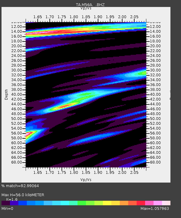
| Estimated Moho Depth: |
56.0 km |
| Estimated Crust Vp/Vs: |
1.60 |
| Assumed Crust Vp: |
6.121 km/s |
| Estimated Crust Vs: |
3.825 km/s |
| Estimated Crust Poisson's Ratio: |
0.18 |
|
| Radial Match: |
92.99064 % |
| Radial Bump: |
367 |
| Transverse Match: |
81.31011 % |
| Transverse Bump: |
400 |
| SOD ConfigId: |
626651 |
| Insert Time: |
2014-04-25 21:12:18.769 +0000 |
| GWidth: |
2.5 |
| Max Bumps: |
400 |
| Tol: |
0.001 |
|
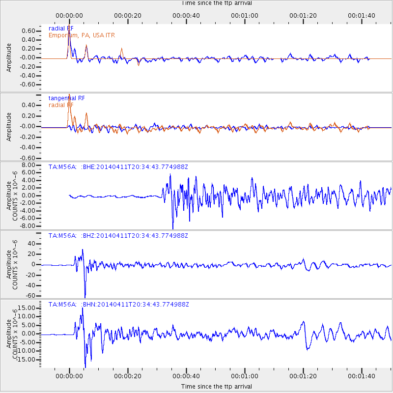
Signal To Noise
| Channel | StoN | STA | LTA |
| TA:M56A: :BHZ:20140411T20:34:43.774988Z | 46.89256 | 1.0686452E-5 | 2.2789227E-7 |
| TA:M56A: :BHN:20140411T20:34:43.774988Z | 28.796976 | 5.341579E-6 | 1.8549096E-7 |
| TA:M56A: :BHE:20140411T20:34:43.774988Z | 9.770374 | 1.8307586E-6 | 1.8737856E-7 |
| Arrivals |
| Ps | 5.9 SECOND |
| PpPs | 22 SECOND |
| PsPs/PpSs | 28 SECOND |


