You are here: Home > Network List > TA - USArray Transportable Network (new EarthScope stations) Stations List
> Station M59A Waymart, PA, USA > Earthquake Result Viewer
M59A Waymart, PA, USA - Earthquake Result Viewer
| Earthquake location: |
Near Coast Of Nicaragua |
| Earthquake latitude/longitude: |
11.6/-86.0 |
| Earthquake time(UTC): |
2014/04/11 (101) 20:29:13 GMT |
| Earthquake Depth: |
135 km |
| Earthquake Magnitude: |
6.6 MWW, 6.6 MWC, 6.6 MWB, 6.6 MI |
| Earthquake Catalog/Contributor: |
NEIC PDE/NEIC COMCAT |
|
| Network: |
TA USArray Transportable Network (new EarthScope stations) |
| Station: |
M59A Waymart, PA, USA |
| Lat/Lon: |
41.54 N/75.43 W |
| Elevation: |
471 m |
|
| Distance: |
31.3 deg |
| Az: |
15.448 deg |
| Baz: |
200.346 deg |
| Ray Param: |
0.07877664 |
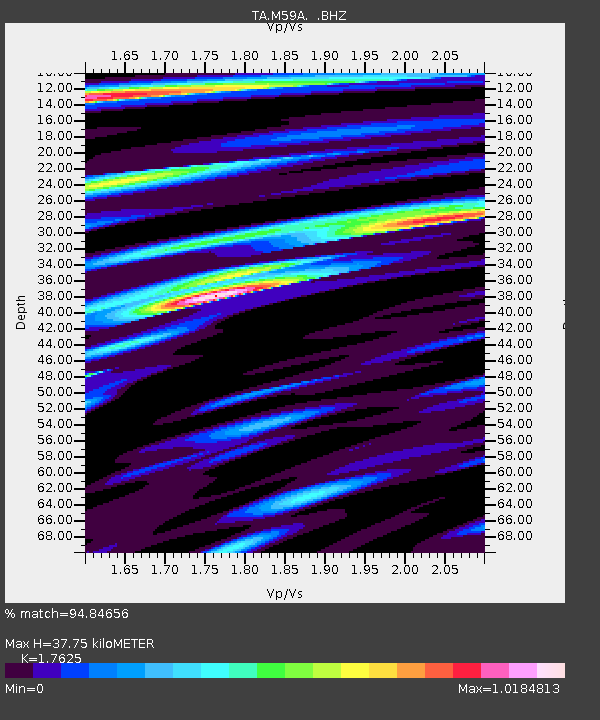
| Estimated Moho Depth: |
37.75 km |
| Estimated Crust Vp/Vs: |
1.76 |
| Assumed Crust Vp: |
6.283 km/s |
| Estimated Crust Vs: |
3.565 km/s |
| Estimated Crust Poisson's Ratio: |
0.26 |
|
| Radial Match: |
94.84656 % |
| Radial Bump: |
400 |
| Transverse Match: |
73.51604 % |
| Transverse Bump: |
400 |
| SOD ConfigId: |
626651 |
| Insert Time: |
2014-04-25 21:12:26.478 +0000 |
| GWidth: |
2.5 |
| Max Bumps: |
400 |
| Tol: |
0.001 |
|
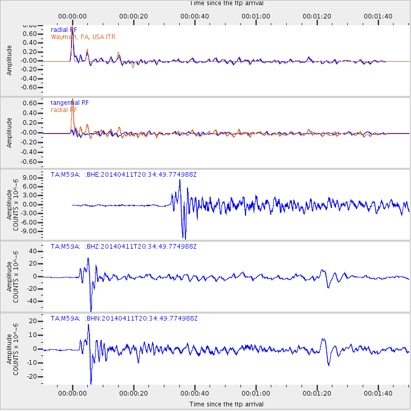
Signal To Noise
| Channel | StoN | STA | LTA |
| TA:M59A: :BHZ:20140411T20:34:49.774988Z | 16.791197 | 7.4374493E-6 | 4.4293742E-7 |
| TA:M59A: :BHN:20140411T20:34:49.774988Z | 19.453323 | 3.361539E-6 | 1.7280024E-7 |
| TA:M59A: :BHE:20140411T20:34:49.774988Z | 15.950591 | 1.8139052E-6 | 1.1372025E-7 |
| Arrivals |
| Ps | 4.9 SECOND |
| PpPs | 15 SECOND |
| PsPs/PpSs | 20 SECOND |


