You are here: Home > Network List > TA - USArray Transportable Network (new EarthScope stations) Stations List
> Station M61A Granite Springs, NY, USA > Earthquake Result Viewer
M61A Granite Springs, NY, USA - Earthquake Result Viewer

| Earthquake location: |
Near Coast Of Nicaragua |
| Earthquake latitude/longitude: |
11.6/-86.0 |
| Earthquake time(UTC): |
2014/04/11 (101) 20:29:13 GMT |
| Earthquake Depth: |
135 km |
| Earthquake Magnitude: |
6.6 MWW, 6.6 MWC, 6.6 MWB, 6.6 MI |
| Earthquake Catalog/Contributor: |
NEIC PDE/NEIC COMCAT |
|
| Network: |
TA USArray Transportable Network (new EarthScope stations) |
| Station: |
M61A Granite Springs, NY, USA |
| Lat/Lon: |
41.31 N/73.77 W |
| Elevation: |
190 m |
|
| Distance: |
31.5 deg |
| Az: |
17.844 deg |
| Baz: |
203.489 deg |
| Ray Param: |
0.07866976 |
| Estimated Moho Depth: |
42.0 km |
| Estimated Crust Vp/Vs: |
1.75 |
| Assumed Crust Vp: |
6.472 km/s |
| Estimated Crust Vs: |
3.698 km/s |
| Estimated Crust Poisson's Ratio: |
0.26 |
|
| Radial Match: |
94.16771 % |
| Radial Bump: |
350 |
| Transverse Match: |
74.76027 % |
| Transverse Bump: |
400 |
| SOD ConfigId: |
626651 |
| Insert Time: |
2014-04-25 21:12:31.206 +0000 |
| GWidth: |
2.5 |
| Max Bumps: |
400 |
| Tol: |
0.001 |
|
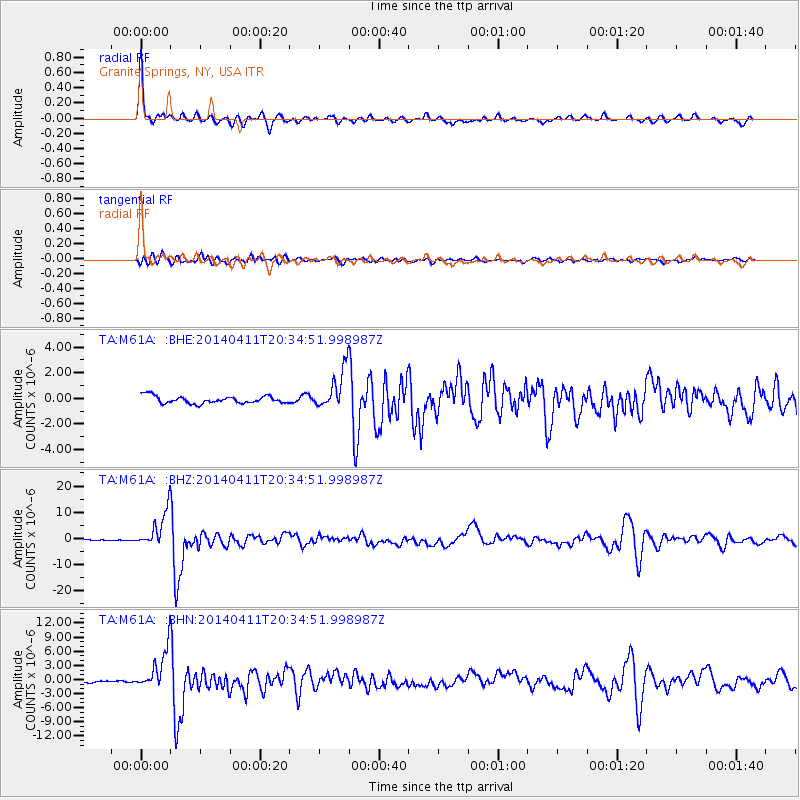
Signal To Noise
| Channel | StoN | STA | LTA |
| TA:M61A: :BHZ:20140411T20:34:51.998987Z | 33.72137 | 7.0029964E-6 | 2.0767234E-7 |
| TA:M61A: :BHN:20140411T20:34:51.998987Z | 20.414673 | 4.3276596E-6 | 2.119877E-7 |
| TA:M61A: :BHE:20140411T20:34:51.998987Z | 5.481469 | 1.563757E-6 | 2.8528063E-7 |
| Arrivals |
| Ps | 5.3 SECOND |
| PpPs | 16 SECOND |
| PsPs/PpSs | 22 SECOND |


