You are here: Home > Network List > TA - USArray Transportable Network (new EarthScope stations) Stations List
> Station M62A Hamden, CT, USA > Earthquake Result Viewer
M62A Hamden, CT, USA - Earthquake Result Viewer
| Earthquake location: |
Near Coast Of Nicaragua |
| Earthquake latitude/longitude: |
11.6/-86.0 |
| Earthquake time(UTC): |
2014/04/11 (101) 20:29:13 GMT |
| Earthquake Depth: |
135 km |
| Earthquake Magnitude: |
6.6 MWW, 6.6 MWC, 6.6 MWB, 6.6 MI |
| Earthquake Catalog/Contributor: |
NEIC PDE/NEIC COMCAT |
|
| Network: |
TA USArray Transportable Network (new EarthScope stations) |
| Station: |
M62A Hamden, CT, USA |
| Lat/Lon: |
41.44 N/72.89 W |
| Elevation: |
24 m |
|
| Distance: |
31.9 deg |
| Az: |
18.882 deg |
| Baz: |
204.947 deg |
| Ray Param: |
0.078505285 |
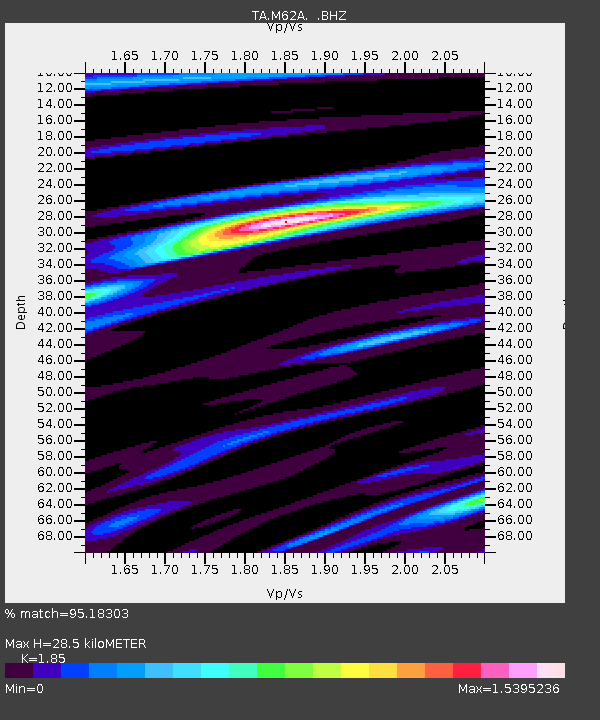
| Estimated Moho Depth: |
28.5 km |
| Estimated Crust Vp/Vs: |
1.85 |
| Assumed Crust Vp: |
6.472 km/s |
| Estimated Crust Vs: |
3.498 km/s |
| Estimated Crust Poisson's Ratio: |
0.29 |
|
| Radial Match: |
95.18303 % |
| Radial Bump: |
322 |
| Transverse Match: |
80.78791 % |
| Transverse Bump: |
400 |
| SOD ConfigId: |
626651 |
| Insert Time: |
2014-04-25 21:12:33.206 +0000 |
| GWidth: |
2.5 |
| Max Bumps: |
400 |
| Tol: |
0.001 |
|

Signal To Noise
| Channel | StoN | STA | LTA |
| TA:M62A: :BHZ:20140411T20:34:55.399988Z | 22.171247 | 7.194428E-6 | 3.2449358E-7 |
| TA:M62A: :BHN:20140411T20:34:55.399988Z | 14.500395 | 4.1240096E-6 | 2.8440672E-7 |
| TA:M62A: :BHE:20140411T20:34:55.399988Z | 8.073758 | 2.7661183E-6 | 3.4260603E-7 |
| Arrivals |
| Ps | 4.0 SECOND |
| PpPs | 12 SECOND |
| PsPs/PpSs | 16 SECOND |


