You are here: Home > Network List > TA - USArray Transportable Network (new EarthScope stations) Stations List
> Station M63A Gales Ferry, CT, USA > Earthquake Result Viewer
M63A Gales Ferry, CT, USA - Earthquake Result Viewer
| Earthquake location: |
Near Coast Of Nicaragua |
| Earthquake latitude/longitude: |
11.6/-86.0 |
| Earthquake time(UTC): |
2014/04/11 (101) 20:29:13 GMT |
| Earthquake Depth: |
135 km |
| Earthquake Magnitude: |
6.6 MWW, 6.6 MWC, 6.6 MWB, 6.6 MI |
| Earthquake Catalog/Contributor: |
NEIC PDE/NEIC COMCAT |
|
| Network: |
TA USArray Transportable Network (new EarthScope stations) |
| Station: |
M63A Gales Ferry, CT, USA |
| Lat/Lon: |
41.40 N/72.05 W |
| Elevation: |
44 m |
|
| Distance: |
32.1 deg |
| Az: |
19.997 deg |
| Baz: |
206.451 deg |
| Ray Param: |
0.078399844 |
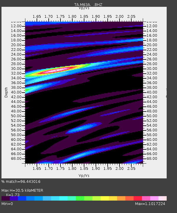
| Estimated Moho Depth: |
30.5 km |
| Estimated Crust Vp/Vs: |
1.73 |
| Assumed Crust Vp: |
6.472 km/s |
| Estimated Crust Vs: |
3.741 km/s |
| Estimated Crust Poisson's Ratio: |
0.25 |
|
| Radial Match: |
96.443016 % |
| Radial Bump: |
250 |
| Transverse Match: |
86.334274 % |
| Transverse Bump: |
400 |
| SOD ConfigId: |
626651 |
| Insert Time: |
2014-04-25 21:12:35.427 +0000 |
| GWidth: |
2.5 |
| Max Bumps: |
400 |
| Tol: |
0.001 |
|

Signal To Noise
| Channel | StoN | STA | LTA |
| TA:M63A: :BHZ:20140411T20:34:57.499994Z | 30.464766 | 6.23476E-6 | 2.0465478E-7 |
| TA:M63A: :BHN:20140411T20:34:57.499994Z | 24.711044 | 3.3564747E-6 | 1.3582893E-7 |
| TA:M63A: :BHE:20140411T20:34:57.499994Z | 9.655889 | 1.9500371E-6 | 2.0195316E-7 |
| Arrivals |
| Ps | 3.7 SECOND |
| PpPs | 12 SECOND |
| PsPs/PpSs | 16 SECOND |


