You are here: Home > Network List > UW - Pacific Northwest Regional Seismic Network Stations List
> Station LEBA Lebam, WA, USA > Earthquake Result Viewer
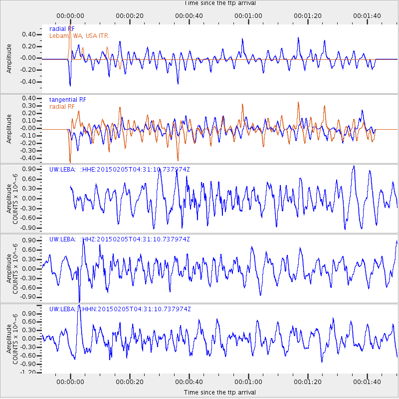
LEBA Lebam, WA, USA - Earthquake Result Viewer
*The percent match for this event was below the threshold and hence no stack was calculated.
| Earthquake location: |
Venezuela |
| Earthquake latitude/longitude: |
8.3/-72.1 |
| Earthquake time(UTC): |
2015/02/05 (036) 04:21:50 GMT |
| Earthquake Depth: |
22 km |
| Earthquake Magnitude: |
5.3 MW |
| Earthquake Catalog/Contributor: |
ISC/ISC |
|
| Network: |
UW Pacific Northwest Regional Seismic Network |
| Station: |
LEBA Lebam, WA, USA |
| Lat/Lon: |
46.55 N/123.56 W |
| Elevation: |
73 m |
|
| Distance: |
58.0 deg |
| Az: |
320.463 deg |
| Baz: |
114.116 deg |
| Ray Param: |
$rayparam |
*The percent match for this event was below the threshold and hence was not used in the summary stack. |
|
| Radial Match: |
46.24181 % |
| Radial Bump: |
400 |
| Transverse Match: |
45.540745 % |
| Transverse Bump: |
400 |
| SOD ConfigId: |
7019011 |
| Insert Time: |
2019-04-16 16:24:09.357 +0000 |
| GWidth: |
2.5 |
| Max Bumps: |
400 |
| Tol: |
0.001 |
|
Signal To Noise
| Channel | StoN | STA | LTA |
| UW:LEBA: :HHZ:20150205T04:31:10.737974Z | 1.8137368 | 4.2980676E-7 | 2.3697307E-7 |
| UW:LEBA: :HHN:20150205T04:31:10.737974Z | 2.4969273 | 6.110785E-7 | 2.447322E-7 |
| UW:LEBA: :HHE:20150205T04:31:10.737974Z | 1.8435861 | 4.9706296E-7 | 2.6961743E-7 |
| Arrivals |
| Ps | |
| PpPs | |
| PsPs/PpSs | |


