You are here: Home > Network List > UW - Pacific Northwest Regional Seismic Network Stations List
> Station UMAT Pilot Rock, OR, USA > Earthquake Result Viewer
UMAT Pilot Rock, OR, USA - Earthquake Result Viewer
*The percent match for this event was below the threshold and hence no stack was calculated.
| Earthquake location: |
Venezuela |
| Earthquake latitude/longitude: |
8.3/-72.1 |
| Earthquake time(UTC): |
2015/02/05 (036) 04:21:50 GMT |
| Earthquake Depth: |
22 km |
| Earthquake Magnitude: |
5.3 MW |
| Earthquake Catalog/Contributor: |
ISC/ISC |
|
| Network: |
UW Pacific Northwest Regional Seismic Network |
| Station: |
UMAT Pilot Rock, OR, USA |
| Lat/Lon: |
45.29 N/118.96 W |
| Elevation: |
1318 m |
|
| Distance: |
54.6 deg |
| Az: |
320.79 deg |
| Baz: |
117.595 deg |
| Ray Param: |
$rayparam |
*The percent match for this event was below the threshold and hence was not used in the summary stack. |
|
| Radial Match: |
47.935234 % |
| Radial Bump: |
400 |
| Transverse Match: |
53.79696 % |
| Transverse Bump: |
395 |
| SOD ConfigId: |
7019011 |
| Insert Time: |
2019-04-16 16:24:13.376 +0000 |
| GWidth: |
2.5 |
| Max Bumps: |
400 |
| Tol: |
0.001 |
|
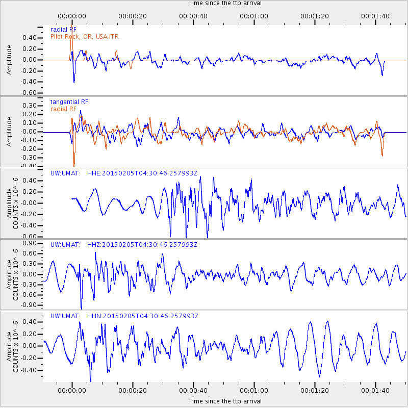
Signal To Noise
| Channel | StoN | STA | LTA |
| UW:UMAT: :HHZ:20150205T04:30:46.257993Z | 1.8741654 | 3.193609E-7 | 1.7040166E-7 |
| UW:UMAT: :HHN:20150205T04:30:46.257993Z | 1.4805143 | 2.153364E-7 | 1.4544703E-7 |
| UW:UMAT: :HHE:20150205T04:30:46.257993Z | 2.0660167 | 2.2810276E-7 | 1.1040703E-7 |
| Arrivals |
| Ps | |
| PpPs | |
| PsPs/PpSs | |


