You are here: Home > Network List > TA - USArray Transportable Network (new EarthScope stations) Stations List
> Station T25A Trinidad, CO, USA > Earthquake Result Viewer
T25A Trinidad, CO, USA - Earthquake Result Viewer
| Earthquake location: |
Near Coast Of Nicaragua |
| Earthquake latitude/longitude: |
11.6/-86.0 |
| Earthquake time(UTC): |
2014/04/11 (101) 20:29:13 GMT |
| Earthquake Depth: |
135 km |
| Earthquake Magnitude: |
6.6 MWW, 6.6 MWC, 6.6 MWB, 6.6 MI |
| Earthquake Catalog/Contributor: |
NEIC PDE/NEIC COMCAT |
|
| Network: |
TA USArray Transportable Network (new EarthScope stations) |
| Station: |
T25A Trinidad, CO, USA |
| Lat/Lon: |
37.14 N/104.41 W |
| Elevation: |
2017 m |
|
| Distance: |
30.3 deg |
| Az: |
330.082 deg |
| Baz: |
142.296 deg |
| Ray Param: |
0.079124704 |
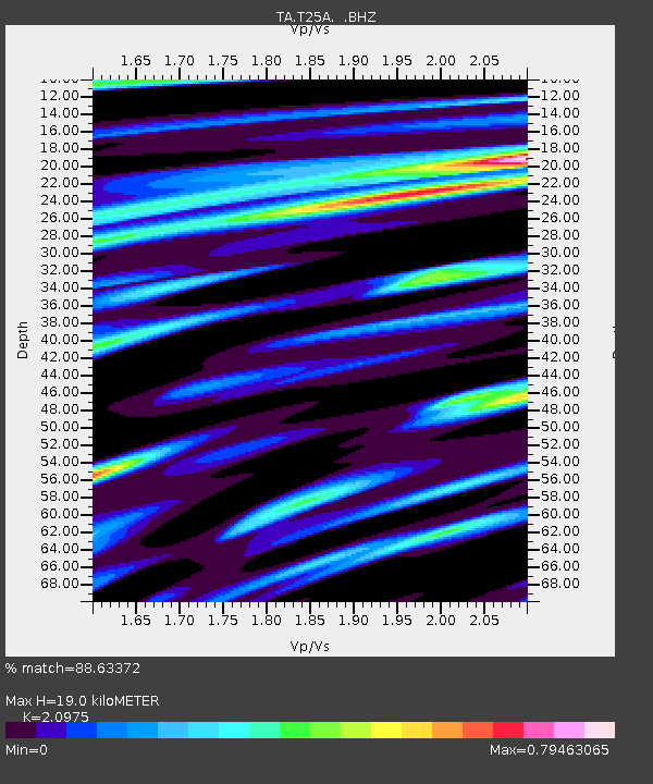
| Estimated Moho Depth: |
19.0 km |
| Estimated Crust Vp/Vs: |
2.10 |
| Assumed Crust Vp: |
6.316 km/s |
| Estimated Crust Vs: |
3.011 km/s |
| Estimated Crust Poisson's Ratio: |
0.35 |
|
| Radial Match: |
88.63372 % |
| Radial Bump: |
371 |
| Transverse Match: |
76.211914 % |
| Transverse Bump: |
400 |
| SOD ConfigId: |
626651 |
| Insert Time: |
2014-04-25 21:13:45.884 +0000 |
| GWidth: |
2.5 |
| Max Bumps: |
400 |
| Tol: |
0.001 |
|
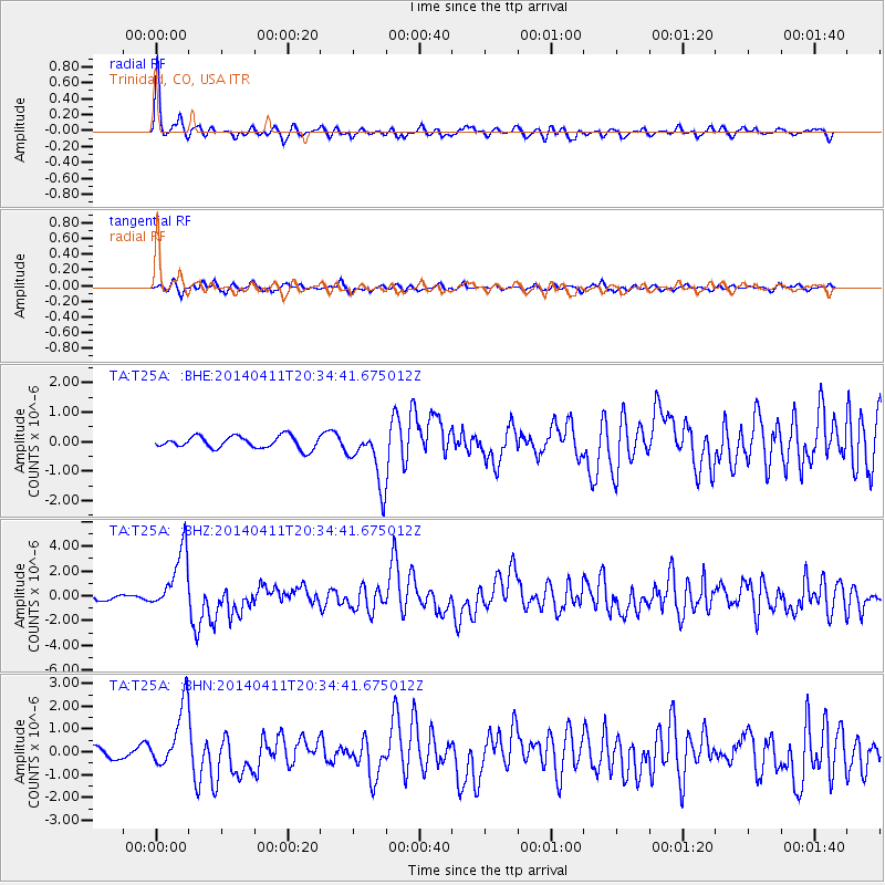
Signal To Noise
| Channel | StoN | STA | LTA |
| TA:T25A: :BHZ:20140411T20:34:41.675012Z | 13.020991 | 2.4478325E-6 | 1.8799125E-7 |
| TA:T25A: :BHN:20140411T20:34:41.675012Z | 5.7998276 | 1.3765344E-6 | 2.3734057E-7 |
| TA:T25A: :BHE:20140411T20:34:41.675012Z | 4.635044 | 9.568611E-7 | 2.0644056E-7 |
| Arrivals |
| Ps | 3.5 SECOND |
| PpPs | 8.7 SECOND |
| PsPs/PpSs | 12 SECOND |


