You are here: Home > Network List > US - United States National Seismic Network Stations List
> Station LBNH Lisbon, New Hampshire, USA > Earthquake Result Viewer
LBNH Lisbon, New Hampshire, USA - Earthquake Result Viewer
| Earthquake location: |
Near Coast Of Nicaragua |
| Earthquake latitude/longitude: |
11.6/-86.0 |
| Earthquake time(UTC): |
2014/04/11 (101) 20:29:13 GMT |
| Earthquake Depth: |
135 km |
| Earthquake Magnitude: |
6.6 MWW, 6.6 MWC, 6.6 MWB, 6.6 MI |
| Earthquake Catalog/Contributor: |
NEIC PDE/NEIC COMCAT |
|
| Network: |
US United States National Seismic Network |
| Station: |
LBNH Lisbon, New Hampshire, USA |
| Lat/Lon: |
44.24 N/71.93 W |
| Elevation: |
367 m |
|
| Distance: |
34.7 deg |
| Az: |
17.917 deg |
| Baz: |
204.797 deg |
| Ray Param: |
0.07713947 |
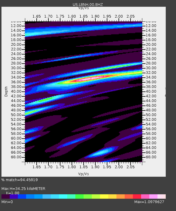
| Estimated Moho Depth: |
34.25 km |
| Estimated Crust Vp/Vs: |
1.88 |
| Assumed Crust Vp: |
6.419 km/s |
| Estimated Crust Vs: |
3.414 km/s |
| Estimated Crust Poisson's Ratio: |
0.30 |
|
| Radial Match: |
94.45919 % |
| Radial Bump: |
264 |
| Transverse Match: |
77.62588 % |
| Transverse Bump: |
400 |
| SOD ConfigId: |
626651 |
| Insert Time: |
2014-04-25 21:14:52.552 +0000 |
| GWidth: |
2.5 |
| Max Bumps: |
400 |
| Tol: |
0.001 |
|
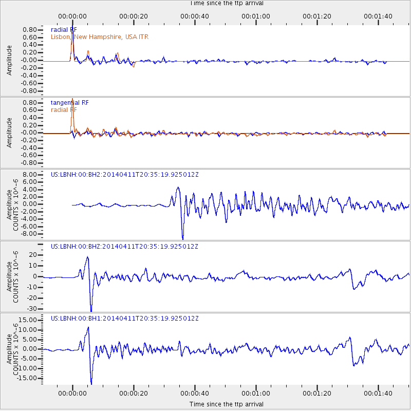
Signal To Noise
| Channel | StoN | STA | LTA |
| US:LBNH:00:BHZ:20140411T20:35:19.925012Z | 25.82965 | 6.5904505E-6 | 2.5515058E-7 |
| US:LBNH:00:BH1:20140411T20:35:19.925012Z | 14.38287 | 3.6633105E-6 | 2.5469956E-7 |
| US:LBNH:00:BH2:20140411T20:35:19.925012Z | 8.955516 | 2.0430236E-6 | 2.2813019E-7 |
| Arrivals |
| Ps | 5.0 SECOND |
| PpPs | 14 SECOND |
| PsPs/PpSs | 19 SECOND |


