You are here: Home > Network List > US - United States National Seismic Network Stations List
> Station MSO Missoula, Montana, USA > Earthquake Result Viewer
MSO Missoula, Montana, USA - Earthquake Result Viewer
*The percent match for this event was below the threshold and hence no stack was calculated.
| Earthquake location: |
Near Coast Of Nicaragua |
| Earthquake latitude/longitude: |
11.6/-86.0 |
| Earthquake time(UTC): |
2014/04/11 (101) 20:29:13 GMT |
| Earthquake Depth: |
135 km |
| Earthquake Magnitude: |
6.6 MWW, 6.6 MWC, 6.6 MWB, 6.6 MI |
| Earthquake Catalog/Contributor: |
NEIC PDE/NEIC COMCAT |
|
| Network: |
US United States National Seismic Network |
| Station: |
MSO Missoula, Montana, USA |
| Lat/Lon: |
46.83 N/113.94 W |
| Elevation: |
1264 m |
|
| Distance: |
42.3 deg |
| Az: |
331.479 deg |
| Baz: |
137.047 deg |
| Ray Param: |
$rayparam |
*The percent match for this event was below the threshold and hence was not used in the summary stack. |
|
| Radial Match: |
71.72865 % |
| Radial Bump: |
400 |
| Transverse Match: |
67.30422 % |
| Transverse Bump: |
400 |
| SOD ConfigId: |
626651 |
| Insert Time: |
2014-04-25 21:14:58.031 +0000 |
| GWidth: |
2.5 |
| Max Bumps: |
400 |
| Tol: |
0.001 |
|
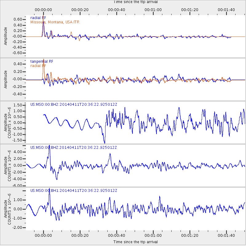
Signal To Noise
| Channel | StoN | STA | LTA |
| US:MSO:00:BHZ:20140411T20:36:22.925012Z | 5.26496 | 2.3524162E-6 | 4.468061E-7 |
| US:MSO:00:BH1:20140411T20:36:22.925012Z | 1.8928465 | 7.43657E-7 | 3.928776E-7 |
| US:MSO:00:BH2:20140411T20:36:22.925012Z | 2.4795988 | 7.8950757E-7 | 3.1840133E-7 |
| Arrivals |
| Ps | |
| PpPs | |
| PsPs/PpSs | |


