You are here: Home > Network List > UU - University of Utah Regional Network Stations List
> Station BSUT Blindstream Canyon, Hanna, UT, USA > Earthquake Result Viewer
BSUT Blindstream Canyon, Hanna, UT, USA - Earthquake Result Viewer
| Earthquake location: |
Near Coast Of Nicaragua |
| Earthquake latitude/longitude: |
11.6/-86.0 |
| Earthquake time(UTC): |
2014/04/11 (101) 20:29:13 GMT |
| Earthquake Depth: |
135 km |
| Earthquake Magnitude: |
6.6 MWW, 6.6 MWC, 6.6 MWB, 6.6 MI |
| Earthquake Catalog/Contributor: |
NEIC PDE/NEIC COMCAT |
|
| Network: |
UU University of Utah Regional Network |
| Station: |
BSUT Blindstream Canyon, Hanna, UT, USA |
| Lat/Lon: |
40.54 N/110.76 W |
| Elevation: |
3211 m |
|
| Distance: |
36.1 deg |
| Az: |
327.284 deg |
| Baz: |
135.983 deg |
| Ray Param: |
0.07638201 |
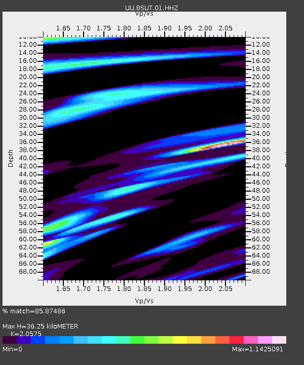
| Estimated Moho Depth: |
36.25 km |
| Estimated Crust Vp/Vs: |
2.06 |
| Assumed Crust Vp: |
6.155 km/s |
| Estimated Crust Vs: |
2.991 km/s |
| Estimated Crust Poisson's Ratio: |
0.35 |
|
| Radial Match: |
85.87486 % |
| Radial Bump: |
400 |
| Transverse Match: |
65.43659 % |
| Transverse Bump: |
400 |
| SOD ConfigId: |
626651 |
| Insert Time: |
2014-04-25 21:15:34.413 +0000 |
| GWidth: |
2.5 |
| Max Bumps: |
400 |
| Tol: |
0.001 |
|

Signal To Noise
| Channel | StoN | STA | LTA |
| UU:BSUT:01:HHZ:20140411T20:35:31.908014Z | 11.811842 | 8.681355E-8 | 7.3497053E-9 |
| UU:BSUT:01:HHN:20140411T20:35:31.908014Z | 9.93004 | 2.7472526E-8 | 2.7666076E-9 |
| UU:BSUT:01:HHE:20140411T20:35:31.908014Z | 5.326401 | 2.9477293E-8 | 5.5341856E-9 |
| Arrivals |
| Ps | 6.6 SECOND |
| PpPs | 17 SECOND |
| PsPs/PpSs | 24 SECOND |


