You are here: Home > Network List > UW - Pacific Northwest Regional Seismic Network Stations List
> Station LEBA Lebam, WA, USA > Earthquake Result Viewer
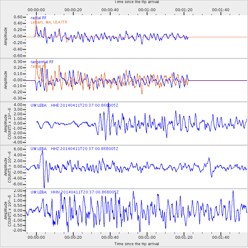
LEBA Lebam, WA, USA - Earthquake Result Viewer
*The percent match for this event was below the threshold and hence no stack was calculated.
| Earthquake location: |
Near Coast Of Nicaragua |
| Earthquake latitude/longitude: |
11.6/-86.0 |
| Earthquake time(UTC): |
2014/04/11 (101) 20:29:13 GMT |
| Earthquake Depth: |
135 km |
| Earthquake Magnitude: |
6.6 MWW, 6.6 MWC, 6.6 MWB, 6.6 MI |
| Earthquake Catalog/Contributor: |
NEIC PDE/NEIC COMCAT |
|
| Network: |
UW Pacific Northwest Regional Seismic Network |
| Station: |
LEBA Lebam, WA, USA |
| Lat/Lon: |
46.55 N/123.56 W |
| Elevation: |
73 m |
|
| Distance: |
47.1 deg |
| Az: |
324.972 deg |
| Baz: |
125.427 deg |
| Ray Param: |
$rayparam |
*The percent match for this event was below the threshold and hence was not used in the summary stack. |
|
| Radial Match: |
69.2494 % |
| Radial Bump: |
400 |
| Transverse Match: |
65.35048 % |
| Transverse Bump: |
394 |
| SOD ConfigId: |
626651 |
| Insert Time: |
2014-04-25 21:17:12.632 +0000 |
| GWidth: |
2.5 |
| Max Bumps: |
400 |
| Tol: |
0.001 |
|
Signal To Noise
| Channel | StoN | STA | LTA |
| UW:LEBA: :HHZ:20140411T20:37:00.868005Z | 7.643711 | 3.1560253E-6 | 4.1289175E-7 |
| UW:LEBA: :HHN:20140411T20:37:00.868005Z | 1.8643626 | 4.914654E-7 | 2.6361042E-7 |
| UW:LEBA: :HHE:20140411T20:37:00.868005Z | 2.9782488 | 1.0886725E-6 | 3.6554115E-7 |
| Arrivals |
| Ps | |
| PpPs | |
| PsPs/PpSs | |


