You are here: Home > Network List > UW - Pacific Northwest Regional Seismic Network Stations List
> Station LRIV Port Angeles, WA, USA > Earthquake Result Viewer
LRIV Port Angeles, WA, USA - Earthquake Result Viewer
| Earthquake location: |
Near Coast Of Nicaragua |
| Earthquake latitude/longitude: |
11.6/-86.0 |
| Earthquake time(UTC): |
2014/04/11 (101) 20:29:13 GMT |
| Earthquake Depth: |
135 km |
| Earthquake Magnitude: |
6.6 MWW, 6.6 MWC, 6.6 MWB, 6.6 MI |
| Earthquake Catalog/Contributor: |
NEIC PDE/NEIC COMCAT |
|
| Network: |
UW Pacific Northwest Regional Seismic Network |
| Station: |
LRIV Port Angeles, WA, USA |
| Lat/Lon: |
48.06 N/123.50 W |
| Elevation: |
294 m |
|
| Distance: |
47.9 deg |
| Az: |
326.663 deg |
| Baz: |
126.612 deg |
| Ray Param: |
0.06920131 |
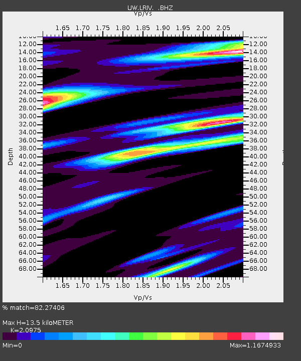
| Estimated Moho Depth: |
13.5 km |
| Estimated Crust Vp/Vs: |
2.10 |
| Assumed Crust Vp: |
6.566 km/s |
| Estimated Crust Vs: |
3.13 km/s |
| Estimated Crust Poisson's Ratio: |
0.35 |
|
| Radial Match: |
82.27406 % |
| Radial Bump: |
400 |
| Transverse Match: |
80.16656 % |
| Transverse Bump: |
400 |
| SOD ConfigId: |
626651 |
| Insert Time: |
2014-04-25 21:17:17.200 +0000 |
| GWidth: |
2.5 |
| Max Bumps: |
400 |
| Tol: |
0.001 |
|

Signal To Noise
| Channel | StoN | STA | LTA |
| UW:LRIV: :BHZ:20140411T20:37:07.48501Z | 11.326664 | 2.642111E-6 | 2.332647E-7 |
| UW:LRIV: :BHN:20140411T20:37:07.48501Z | 2.6612577 | 8.4701145E-7 | 3.1827486E-7 |
| UW:LRIV: :BHE:20140411T20:37:07.48501Z | 3.7188237 | 1.3846973E-6 | 3.7234818E-7 |
| Arrivals |
| Ps | 2.4 SECOND |
| PpPs | 6.0 SECOND |
| PsPs/PpSs | 8.4 SECOND |


