You are here: Home > Network List > CN - Canadian National Seismograph Network Stations List
> Station INK INUVIK, NT > Earthquake Result Viewer
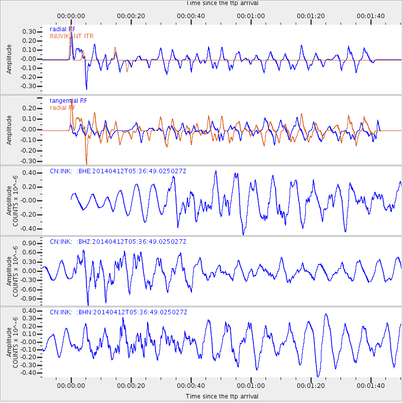
INK INUVIK, NT - Earthquake Result Viewer
*The percent match for this event was below the threshold and hence no stack was calculated.
| Earthquake location: |
Solomon Islands |
| Earthquake latitude/longitude: |
-7.1/155.2 |
| Earthquake time(UTC): |
2014/04/12 (102) 05:24:25 GMT |
| Earthquake Depth: |
35 km |
| Earthquake Magnitude: |
6.1 MWW, 6.2 MWC |
| Earthquake Catalog/Contributor: |
NEIC PDE/NEIC COMCAT |
|
| Network: |
CN Canadian National Seismograph Network |
| Station: |
INK INUVIK, NT |
| Lat/Lon: |
68.31 N/133.53 W |
| Elevation: |
44 m |
|
| Distance: |
89.7 deg |
| Az: |
20.612 deg |
| Baz: |
249.998 deg |
| Ray Param: |
$rayparam |
*The percent match for this event was below the threshold and hence was not used in the summary stack. |
|
| Radial Match: |
79.58585 % |
| Radial Bump: |
400 |
| Transverse Match: |
65.99882 % |
| Transverse Bump: |
400 |
| SOD ConfigId: |
626651 |
| Insert Time: |
2014-04-26 05:41:43.759 +0000 |
| GWidth: |
2.5 |
| Max Bumps: |
400 |
| Tol: |
0.001 |
|
Signal To Noise
| Channel | StoN | STA | LTA |
| CN:INK: :BHZ:20140412T05:36:49.025027Z | 2.3605044 | 3.4019985E-7 | 1.4412167E-7 |
| CN:INK: :BHN:20140412T05:36:49.025027Z | 1.3492157 | 9.4017814E-8 | 6.96833E-8 |
| CN:INK: :BHE:20140412T05:36:49.025027Z | 1.6032388 | 1.8806391E-7 | 1.17302484E-7 |
| Arrivals |
| Ps | |
| PpPs | |
| PsPs/PpSs | |


