You are here: Home > Network List > AK - Alaska Regional Network Stations List
> Station ATKA Atka Island Broadband > Earthquake Result Viewer
ATKA Atka Island Broadband - Earthquake Result Viewer
| Earthquake location: |
Solomon Islands |
| Earthquake latitude/longitude: |
-11.3/162.2 |
| Earthquake time(UTC): |
2014/04/12 (102) 20:14:39 GMT |
| Earthquake Depth: |
29 km |
| Earthquake Magnitude: |
7.6 MWW, 8.3 MI |
| Earthquake Catalog/Contributor: |
NEIC PDE/NEIC COMCAT |
|
| Network: |
AK Alaska Regional Network |
| Station: |
ATKA Atka Island Broadband |
| Lat/Lon: |
52.20 N/174.20 W |
| Elevation: |
55 m |
|
| Distance: |
66.5 deg |
| Az: |
15.587 deg |
| Baz: |
205.355 deg |
| Ray Param: |
0.05756421 |
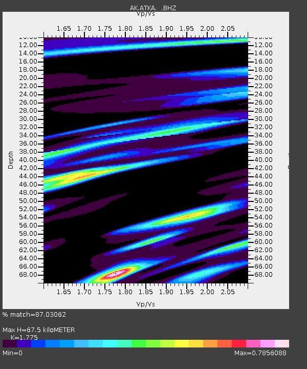
| Estimated Moho Depth: |
67.5 km |
| Estimated Crust Vp/Vs: |
1.77 |
| Assumed Crust Vp: |
5.88 km/s |
| Estimated Crust Vs: |
3.313 km/s |
| Estimated Crust Poisson's Ratio: |
0.27 |
|
| Radial Match: |
87.03062 % |
| Radial Bump: |
400 |
| Transverse Match: |
88.043045 % |
| Transverse Bump: |
400 |
| SOD ConfigId: |
626651 |
| Insert Time: |
2014-04-26 20:33:42.564 +0000 |
| GWidth: |
2.5 |
| Max Bumps: |
400 |
| Tol: |
0.001 |
|

Signal To Noise
| Channel | StoN | STA | LTA |
| AK:ATKA: :BHZ:20140412T20:24:55.227971Z | 22.424074 | 1.748621E-5 | 7.797964E-7 |
| AK:ATKA: :BHN:20140412T20:24:55.227971Z | 11.559299 | 6.9409025E-6 | 6.004605E-7 |
| AK:ATKA: :BHE:20140412T20:24:55.227971Z | 2.100972 | 3.0826793E-6 | 1.4672634E-6 |
| Arrivals |
| Ps | 9.2 SECOND |
| PpPs | 31 SECOND |
| PsPs/PpSs | 40 SECOND |


