You are here: Home > Network List > AK - Alaska Regional Network Stations List
> Station COLD Coldfoot Broadband > Earthquake Result Viewer
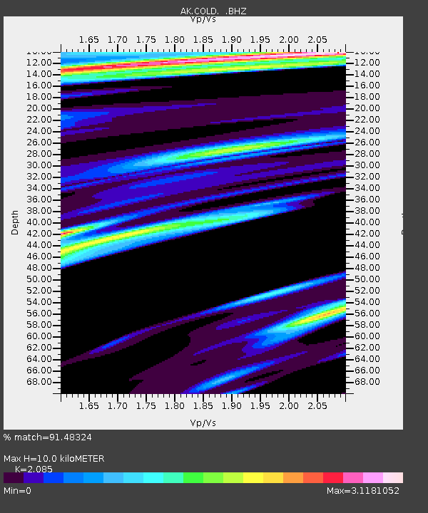
COLD Coldfoot Broadband - Earthquake Result Viewer
| Earthquake location: |
Solomon Islands |
| Earthquake latitude/longitude: |
-11.3/162.2 |
| Earthquake time(UTC): |
2014/04/12 (102) 20:14:39 GMT |
| Earthquake Depth: |
29 km |
| Earthquake Magnitude: |
7.6 MWW, 8.3 MI |
| Earthquake Catalog/Contributor: |
NEIC PDE/NEIC COMCAT |
|
| Network: |
AK Alaska Regional Network |
| Station: |
COLD Coldfoot Broadband |
| Lat/Lon: |
67.23 N/150.20 W |
| Elevation: |
377 m |
|
| Distance: |
85.5 deg |
| Az: |
16.756 deg |
| Baz: |
226.582 deg |
| Ray Param: |
0.044663746 |
| Estimated Moho Depth: |
10.0 km |
| Estimated Crust Vp/Vs: |
2.09 |
| Assumed Crust Vp: |
6.577 km/s |
| Estimated Crust Vs: |
3.154 km/s |
| Estimated Crust Poisson's Ratio: |
0.35 |
|
| Radial Match: |
91.48324 % |
| Radial Bump: |
339 |
| Transverse Match: |
72.74089 % |
| Transverse Bump: |
400 |
| SOD ConfigId: |
626651 |
| Insert Time: |
2014-04-26 20:34:12.953 +0000 |
| GWidth: |
2.5 |
| Max Bumps: |
400 |
| Tol: |
0.001 |
|

Signal To Noise
| Channel | StoN | STA | LTA |
| AK:COLD: :BHZ:20140412T20:26:43.52802Z | 21.052748 | 1.1542402E-6 | 5.4826106E-8 |
| AK:COLD: :BHN:20140412T20:26:43.52802Z | 19.556576 | 2.702009E-6 | 1.381637E-7 |
| AK:COLD: :BHE:20140412T20:26:43.52802Z | 21.005983 | 2.8641703E-6 | 1.3635021E-7 |
| Arrivals |
| Ps | 1.7 SECOND |
| PpPs | 4.6 SECOND |
| PsPs/PpSs | 6.3 SECOND |


