You are here: Home > Network List > AK - Alaska Regional Network Stations List
> Station EYAK Cordova Ski Area > Earthquake Result Viewer
EYAK Cordova Ski Area - Earthquake Result Viewer
| Earthquake location: |
Solomon Islands |
| Earthquake latitude/longitude: |
-11.3/162.2 |
| Earthquake time(UTC): |
2014/04/12 (102) 20:14:39 GMT |
| Earthquake Depth: |
29 km |
| Earthquake Magnitude: |
7.6 MWW, 8.3 MI |
| Earthquake Catalog/Contributor: |
NEIC PDE/NEIC COMCAT |
|
| Network: |
AK Alaska Regional Network |
| Station: |
EYAK Cordova Ski Area |
| Lat/Lon: |
60.55 N/145.75 W |
| Elevation: |
146 m |
|
| Distance: |
82.6 deg |
| Az: |
23.135 deg |
| Baz: |
231.243 deg |
| Ray Param: |
0.04673338 |
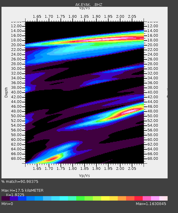
| Estimated Moho Depth: |
17.5 km |
| Estimated Crust Vp/Vs: |
1.92 |
| Assumed Crust Vp: |
6.566 km/s |
| Estimated Crust Vs: |
3.415 km/s |
| Estimated Crust Poisson's Ratio: |
0.31 |
|
| Radial Match: |
90.98375 % |
| Radial Bump: |
400 |
| Transverse Match: |
81.801346 % |
| Transverse Bump: |
400 |
| SOD ConfigId: |
626651 |
| Insert Time: |
2014-04-26 20:34:26.647 +0000 |
| GWidth: |
2.5 |
| Max Bumps: |
400 |
| Tol: |
0.001 |
|

Signal To Noise
| Channel | StoN | STA | LTA |
| AK:EYAK: :BHZ:20140412T20:26:28.708013Z | 47.05188 | 6.0881684E-6 | 1.2939267E-7 |
| AK:EYAK: :BHN:20140412T20:26:28.708013Z | 7.941961 | 1.6302831E-6 | 2.0527463E-7 |
| AK:EYAK: :BHE:20140412T20:26:28.708013Z | 13.264642 | 1.8435165E-6 | 1.3897974E-7 |
| Arrivals |
| Ps | 2.5 SECOND |
| PpPs | 7.6 SECOND |
| PsPs/PpSs | 10 SECOND |


