You are here: Home > Network List > AK - Alaska Regional Network Stations List
> Station GHO Gloryhole, AK, USA > Earthquake Result Viewer
GHO Gloryhole, AK, USA - Earthquake Result Viewer
| Earthquake location: |
Solomon Islands |
| Earthquake latitude/longitude: |
-11.3/162.2 |
| Earthquake time(UTC): |
2014/04/12 (102) 20:14:39 GMT |
| Earthquake Depth: |
29 km |
| Earthquake Magnitude: |
7.6 MWW, 8.3 MI |
| Earthquake Catalog/Contributor: |
NEIC PDE/NEIC COMCAT |
|
| Network: |
AK Alaska Regional Network |
| Station: |
GHO Gloryhole, AK, USA |
| Lat/Lon: |
61.77 N/148.92 W |
| Elevation: |
1038 m |
|
| Distance: |
82.2 deg |
| Az: |
21.187 deg |
| Baz: |
228.208 deg |
| Ray Param: |
0.046998218 |
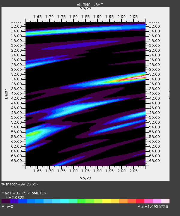
| Estimated Moho Depth: |
32.75 km |
| Estimated Crust Vp/Vs: |
2.08 |
| Assumed Crust Vp: |
6.566 km/s |
| Estimated Crust Vs: |
3.153 km/s |
| Estimated Crust Poisson's Ratio: |
0.35 |
|
| Radial Match: |
94.72657 % |
| Radial Bump: |
400 |
| Transverse Match: |
86.01191 % |
| Transverse Bump: |
400 |
| SOD ConfigId: |
626651 |
| Insert Time: |
2014-04-26 20:34:39.501 +0000 |
| GWidth: |
2.5 |
| Max Bumps: |
400 |
| Tol: |
0.001 |
|

Signal To Noise
| Channel | StoN | STA | LTA |
| AK:GHO: :BHZ:20140412T20:26:26.727971Z | 39.462524 | 8.217629E-6 | 2.082388E-7 |
| AK:GHO: :BHN:20140412T20:26:26.727971Z | 10.037094 | 2.1578642E-6 | 2.1498894E-7 |
| AK:GHO: :BHE:20140412T20:26:26.727971Z | 11.145558 | 2.2954914E-6 | 2.059557E-7 |
| Arrivals |
| Ps | 5.5 SECOND |
| PpPs | 15 SECOND |
| PsPs/PpSs | 21 SECOND |


