You are here: Home > Network List > AK - Alaska Regional Network Stations List
> Station GRNC Granite Creek, AK, USA > Earthquake Result Viewer
GRNC Granite Creek, AK, USA - Earthquake Result Viewer
| Earthquake location: |
Solomon Islands |
| Earthquake latitude/longitude: |
-11.3/162.2 |
| Earthquake time(UTC): |
2014/04/12 (102) 20:14:39 GMT |
| Earthquake Depth: |
29 km |
| Earthquake Magnitude: |
7.6 MWW, 8.3 MI |
| Earthquake Catalog/Contributor: |
NEIC PDE/NEIC COMCAT |
|
| Network: |
AK Alaska Regional Network |
| Station: |
GRNC Granite Creek, AK, USA |
| Lat/Lon: |
60.73 N/141.76 W |
| Elevation: |
2116 m |
|
| Distance: |
84.3 deg |
| Az: |
24.179 deg |
| Baz: |
234.836 deg |
| Ray Param: |
0.045553755 |
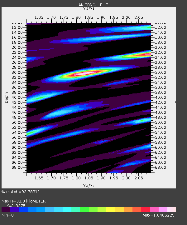
| Estimated Moho Depth: |
30.0 km |
| Estimated Crust Vp/Vs: |
1.84 |
| Assumed Crust Vp: |
6.566 km/s |
| Estimated Crust Vs: |
3.573 km/s |
| Estimated Crust Poisson's Ratio: |
0.29 |
|
| Radial Match: |
93.78311 % |
| Radial Bump: |
400 |
| Transverse Match: |
81.16451 % |
| Transverse Bump: |
400 |
| SOD ConfigId: |
626651 |
| Insert Time: |
2014-04-26 20:34:49.406 +0000 |
| GWidth: |
2.5 |
| Max Bumps: |
400 |
| Tol: |
0.001 |
|

Signal To Noise
| Channel | StoN | STA | LTA |
| AK:GRNC: :BHZ:20140412T20:26:37.328008Z | 25.952574 | 4.8795537E-6 | 1.8801812E-7 |
| AK:GRNC: :BHN:20140412T20:26:37.328008Z | 10.930409 | 1.2485582E-6 | 1.1422794E-7 |
| AK:GRNC: :BHE:20140412T20:26:37.328008Z | 12.637633 | 1.2376216E-6 | 9.793144E-8 |
| Arrivals |
| Ps | 3.9 SECOND |
| PpPs | 13 SECOND |
| PsPs/PpSs | 17 SECOND |


