You are here: Home > Network List > AK - Alaska Regional Network Stations List
> Station SAW Sawmill > Earthquake Result Viewer
SAW Sawmill - Earthquake Result Viewer
| Earthquake location: |
Solomon Islands |
| Earthquake latitude/longitude: |
-11.3/162.2 |
| Earthquake time(UTC): |
2014/04/12 (102) 20:14:39 GMT |
| Earthquake Depth: |
29 km |
| Earthquake Magnitude: |
7.6 MWW, 8.3 MI |
| Earthquake Catalog/Contributor: |
NEIC PDE/NEIC COMCAT |
|
| Network: |
AK Alaska Regional Network |
| Station: |
SAW Sawmill |
| Lat/Lon: |
61.81 N/148.33 W |
| Elevation: |
782 m |
|
| Distance: |
82.5 deg |
| Az: |
21.349 deg |
| Baz: |
228.752 deg |
| Ray Param: |
0.046835203 |
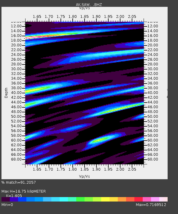
| Estimated Moho Depth: |
16.75 km |
| Estimated Crust Vp/Vs: |
1.61 |
| Assumed Crust Vp: |
6.566 km/s |
| Estimated Crust Vs: |
4.091 km/s |
| Estimated Crust Poisson's Ratio: |
0.18 |
|
| Radial Match: |
91.2057 % |
| Radial Bump: |
400 |
| Transverse Match: |
80.6846 % |
| Transverse Bump: |
400 |
| SOD ConfigId: |
626651 |
| Insert Time: |
2014-04-26 20:35:50.874 +0000 |
| GWidth: |
2.5 |
| Max Bumps: |
400 |
| Tol: |
0.001 |
|

Signal To Noise
| Channel | StoN | STA | LTA |
| AK:SAW: :BHZ:20140412T20:26:27.948003Z | 34.084362 | 8.23323E-6 | 2.4155446E-7 |
| AK:SAW: :BHN:20140412T20:26:27.948003Z | 8.628155 | 1.5743979E-6 | 1.8247214E-7 |
| AK:SAW: :BHE:20140412T20:26:27.948003Z | 11.89497 | 2.2676793E-6 | 1.9064188E-7 |
| Arrivals |
| Ps | 1.6 SECOND |
| PpPs | 6.4 SECOND |
| PsPs/PpSs | 8.0 SECOND |


