You are here: Home > Network List > AK - Alaska Regional Network Stations List
> Station WAT1 Susitna Watana 1, AK, USA > Earthquake Result Viewer
WAT1 Susitna Watana 1, AK, USA - Earthquake Result Viewer
| Earthquake location: |
Solomon Islands |
| Earthquake latitude/longitude: |
-11.3/162.2 |
| Earthquake time(UTC): |
2014/04/12 (102) 20:14:39 GMT |
| Earthquake Depth: |
29 km |
| Earthquake Magnitude: |
7.6 MWW, 8.3 MI |
| Earthquake Catalog/Contributor: |
NEIC PDE/NEIC COMCAT |
|
| Network: |
AK Alaska Regional Network |
| Station: |
WAT1 Susitna Watana 1, AK, USA |
| Lat/Lon: |
62.83 N/148.55 W |
| Elevation: |
722 m |
|
| Distance: |
83.1 deg |
| Az: |
20.504 deg |
| Baz: |
228.45 deg |
| Ray Param: |
0.04641793 |
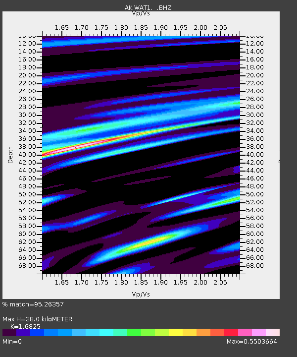
| Estimated Moho Depth: |
38.0 km |
| Estimated Crust Vp/Vs: |
1.68 |
| Assumed Crust Vp: |
6.566 km/s |
| Estimated Crust Vs: |
3.903 km/s |
| Estimated Crust Poisson's Ratio: |
0.23 |
|
| Radial Match: |
95.26357 % |
| Radial Bump: |
400 |
| Transverse Match: |
85.3507 % |
| Transverse Bump: |
400 |
| SOD ConfigId: |
626651 |
| Insert Time: |
2014-04-26 20:36:20.617 +0000 |
| GWidth: |
2.5 |
| Max Bumps: |
400 |
| Tol: |
0.001 |
|

Signal To Noise
| Channel | StoN | STA | LTA |
| AK:WAT1: :BHZ:20140412T20:26:31.067998Z | 63.375668 | 1.0734174E-5 | 1.6937375E-7 |
| AK:WAT1: :BHN:20140412T20:26:31.067998Z | 20.196728 | 2.258955E-6 | 1.1184757E-7 |
| AK:WAT1: :BHE:20140412T20:26:31.067998Z | 20.5271 | 3.1924133E-6 | 1.5552189E-7 |
| Arrivals |
| Ps | 4.1 SECOND |
| PpPs | 15 SECOND |
| PsPs/PpSs | 19 SECOND |


