You are here: Home > Network List > CC - Cascade Chain Volcano Monitoring Stations List
> Station TCBU Trout Creek Butte at 3-Sisters, OR > Earthquake Result Viewer
TCBU Trout Creek Butte at 3-Sisters, OR - Earthquake Result Viewer
| Earthquake location: |
Solomon Islands |
| Earthquake latitude/longitude: |
-11.3/162.2 |
| Earthquake time(UTC): |
2014/04/12 (102) 20:14:39 GMT |
| Earthquake Depth: |
29 km |
| Earthquake Magnitude: |
7.6 MWW, 8.3 MI |
| Earthquake Catalog/Contributor: |
NEIC PDE/NEIC COMCAT |
|
| Network: |
CC Cascade Chain Volcano Monitoring |
| Station: |
TCBU Trout Creek Butte at 3-Sisters, OR |
| Lat/Lon: |
44.24 N/121.66 W |
| Elevation: |
1646 m |
|
| Distance: |
88.1 deg |
| Az: |
44.28 deg |
| Baz: |
252.313 deg |
| Ray Param: |
0.042818394 |
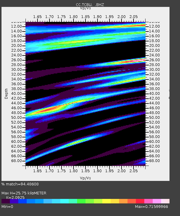
| Estimated Moho Depth: |
25.75 km |
| Estimated Crust Vp/Vs: |
2.09 |
| Assumed Crust Vp: |
6.597 km/s |
| Estimated Crust Vs: |
3.153 km/s |
| Estimated Crust Poisson's Ratio: |
0.35 |
|
| Radial Match: |
94.48608 % |
| Radial Bump: |
326 |
| Transverse Match: |
87.170166 % |
| Transverse Bump: |
400 |
| SOD ConfigId: |
626651 |
| Insert Time: |
2014-04-26 20:40:01.649 +0000 |
| GWidth: |
2.5 |
| Max Bumps: |
400 |
| Tol: |
0.001 |
|

Signal To Noise
| Channel | StoN | STA | LTA |
| CC:TCBU: :BHZ:20140412T20:26:55.919988Z | 6.025348 | 1.0091495E-6 | 1.67484E-7 |
| CC:TCBU: :BHN:20140412T20:26:55.919988Z | 2.079958 | 1.3723596E-6 | 6.5980163E-7 |
| CC:TCBU: :BHE:20140412T20:26:55.919988Z | 2.081488 | 1.1123028E-6 | 5.343787E-7 |
| Arrivals |
| Ps | 4.3 SECOND |
| PpPs | 12 SECOND |
| PsPs/PpSs | 16 SECOND |


