You are here: Home > Network List > CN - Canadian National Seismograph Network Stations List
> Station INK INUVIK, NT > Earthquake Result Viewer
INK INUVIK, NT - Earthquake Result Viewer

| Earthquake location: |
Solomon Islands |
| Earthquake latitude/longitude: |
-11.3/162.2 |
| Earthquake time(UTC): |
2014/04/12 (102) 20:14:39 GMT |
| Earthquake Depth: |
29 km |
| Earthquake Magnitude: |
7.6 MWW, 8.3 MI |
| Earthquake Catalog/Contributor: |
NEIC PDE/NEIC COMCAT |
|
| Network: |
CN Canadian National Seismograph Network |
| Station: |
INK INUVIK, NT |
| Lat/Lon: |
68.31 N/133.53 W |
| Elevation: |
44 m |
|
| Distance: |
91.3 deg |
| Az: |
19.572 deg |
| Baz: |
242.097 deg |
| Ray Param: |
0.04160889 |
| Estimated Moho Depth: |
23.25 km |
| Estimated Crust Vp/Vs: |
1.70 |
| Assumed Crust Vp: |
6.171 km/s |
| Estimated Crust Vs: |
3.63 km/s |
| Estimated Crust Poisson's Ratio: |
0.24 |
|
| Radial Match: |
96.71529 % |
| Radial Bump: |
293 |
| Transverse Match: |
84.747925 % |
| Transverse Bump: |
400 |
| SOD ConfigId: |
626651 |
| Insert Time: |
2014-04-26 20:41:29.978 +0000 |
| GWidth: |
2.5 |
| Max Bumps: |
400 |
| Tol: |
0.001 |
|
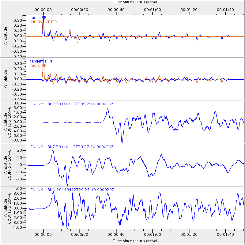
Signal To Noise
| Channel | StoN | STA | LTA |
| CN:INK: :BHZ:20140412T20:27:10.900029Z | 48.90406 | 5.3344247E-6 | 1.0907938E-7 |
| CN:INK: :BHN:20140412T20:27:10.900029Z | 8.4552 | 8.6343726E-7 | 1.0211908E-7 |
| CN:INK: :BHE:20140412T20:27:10.900029Z | 12.499509 | 1.4338752E-6 | 1.14714524E-7 |
| Arrivals |
| Ps | 2.7 SECOND |
| PpPs | 10.0 SECOND |
| PsPs/PpSs | 13 SECOND |


