You are here: Home > Network List > CN - Canadian National Seismograph Network Stations List
> Station LLLB LILLOOET, BC, CANADA ADA > Earthquake Result Viewer
LLLB LILLOOET, BC, CANADA ADA - Earthquake Result Viewer

| Earthquake location: |
Solomon Islands |
| Earthquake latitude/longitude: |
-11.3/162.2 |
| Earthquake time(UTC): |
2014/04/12 (102) 20:14:39 GMT |
| Earthquake Depth: |
29 km |
| Earthquake Magnitude: |
7.6 MWW, 8.3 MI |
| Earthquake Catalog/Contributor: |
NEIC PDE/NEIC COMCAT |
|
| Network: |
CN Canadian National Seismograph Network |
| Station: |
LLLB LILLOOET, BC, CANADA ADA |
| Lat/Lon: |
50.61 N/121.88 W |
| Elevation: |
700 m |
|
| Distance: |
89.9 deg |
| Az: |
38.169 deg |
| Baz: |
252.045 deg |
| Ray Param: |
0.041709166 |
| Estimated Moho Depth: |
14.5 km |
| Estimated Crust Vp/Vs: |
1.92 |
| Assumed Crust Vp: |
6.597 km/s |
| Estimated Crust Vs: |
3.432 km/s |
| Estimated Crust Poisson's Ratio: |
0.31 |
|
| Radial Match: |
94.78149 % |
| Radial Bump: |
400 |
| Transverse Match: |
76.36421 % |
| Transverse Bump: |
400 |
| SOD ConfigId: |
626651 |
| Insert Time: |
2014-04-26 20:41:30.773 +0000 |
| GWidth: |
2.5 |
| Max Bumps: |
400 |
| Tol: |
0.001 |
|
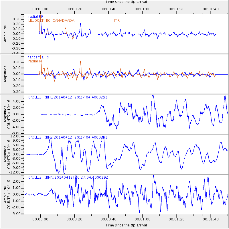
Signal To Noise
| Channel | StoN | STA | LTA |
| CN:LLLB: :BHZ:20140412T20:27:04.400029Z | 12.869336 | 1.9049846E-6 | 1.480251E-7 |
| CN:LLLB: :BHN:20140412T20:27:04.400029Z | 1.2292714 | 1.2193658E-7 | 9.919419E-8 |
| CN:LLLB: :BHE:20140412T20:27:04.400029Z | 3.9262977 | 5.038297E-7 | 1.2832183E-7 |
| Arrivals |
| Ps | 2.1 SECOND |
| PpPs | 6.3 SECOND |
| PsPs/PpSs | 8.4 SECOND |


