You are here: Home > Network List > CN - Canadian National Seismograph Network Stations List
> Station VIB VAN INLET, BC > Earthquake Result Viewer
VIB VAN INLET, BC - Earthquake Result Viewer
| Earthquake location: |
Solomon Islands |
| Earthquake latitude/longitude: |
-11.3/162.2 |
| Earthquake time(UTC): |
2014/04/12 (102) 20:14:39 GMT |
| Earthquake Depth: |
29 km |
| Earthquake Magnitude: |
7.6 MWW, 8.3 MI |
| Earthquake Catalog/Contributor: |
NEIC PDE/NEIC COMCAT |
|
| Network: |
CN Canadian National Seismograph Network |
| Station: |
VIB VAN INLET, BC |
| Lat/Lon: |
53.25 N/132.54 W |
| Elevation: |
1008 m |
|
| Distance: |
84.8 deg |
| Az: |
33.226 deg |
| Baz: |
243.433 deg |
| Ray Param: |
0.045199003 |
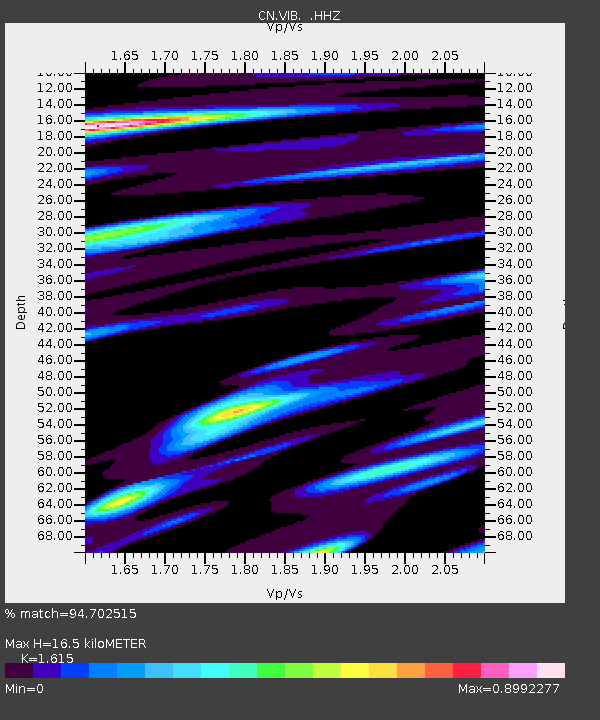
| Estimated Moho Depth: |
16.5 km |
| Estimated Crust Vp/Vs: |
1.62 |
| Assumed Crust Vp: |
6.183 km/s |
| Estimated Crust Vs: |
3.828 km/s |
| Estimated Crust Poisson's Ratio: |
0.19 |
|
| Radial Match: |
94.702515 % |
| Radial Bump: |
400 |
| Transverse Match: |
84.13176 % |
| Transverse Bump: |
400 |
| SOD ConfigId: |
626651 |
| Insert Time: |
2014-04-26 20:41:52.660 +0000 |
| GWidth: |
2.5 |
| Max Bumps: |
400 |
| Tol: |
0.001 |
|
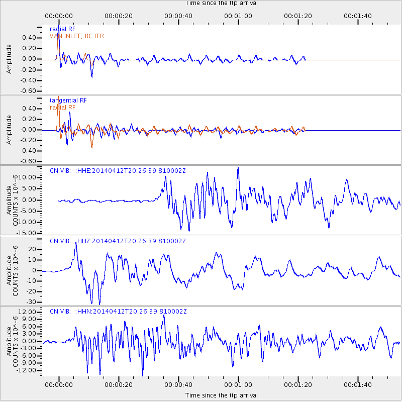
Signal To Noise
| Channel | StoN | STA | LTA |
| CN:VIB: :HHZ:20140412T20:26:39.810002Z | 8.578681 | 4.0072637E-6 | 4.6711887E-7 |
| CN:VIB: :HHN:20140412T20:26:39.810002Z | 1.6242195 | 7.046862E-7 | 4.3386143E-7 |
| CN:VIB: :HHE:20140412T20:26:39.810002Z | 5.3737326 | 1.8700946E-6 | 3.4800664E-7 |
| Arrivals |
| Ps | 1.7 SECOND |
| PpPs | 6.8 SECOND |
| PsPs/PpSs | 8.5 SECOND |


