You are here: Home > Network List > IU - Global Seismograph Network (GSN - IRIS/USGS) Stations List
> Station GUMO Guam, Mariana Islands > Earthquake Result Viewer
GUMO Guam, Mariana Islands - Earthquake Result Viewer
| Earthquake location: |
Solomon Islands |
| Earthquake latitude/longitude: |
-11.3/162.2 |
| Earthquake time(UTC): |
2014/04/12 (102) 20:14:39 GMT |
| Earthquake Depth: |
29 km |
| Earthquake Magnitude: |
7.6 MWW, 8.3 MI |
| Earthquake Catalog/Contributor: |
NEIC PDE/NEIC COMCAT |
|
| Network: |
IU Global Seismograph Network (GSN - IRIS/USGS) |
| Station: |
GUMO Guam, Mariana Islands |
| Lat/Lon: |
13.59 N/144.87 E |
| Elevation: |
170 m |
|
| Distance: |
30.1 deg |
| Az: |
324.736 deg |
| Baz: |
144.384 deg |
| Ray Param: |
0.07938578 |
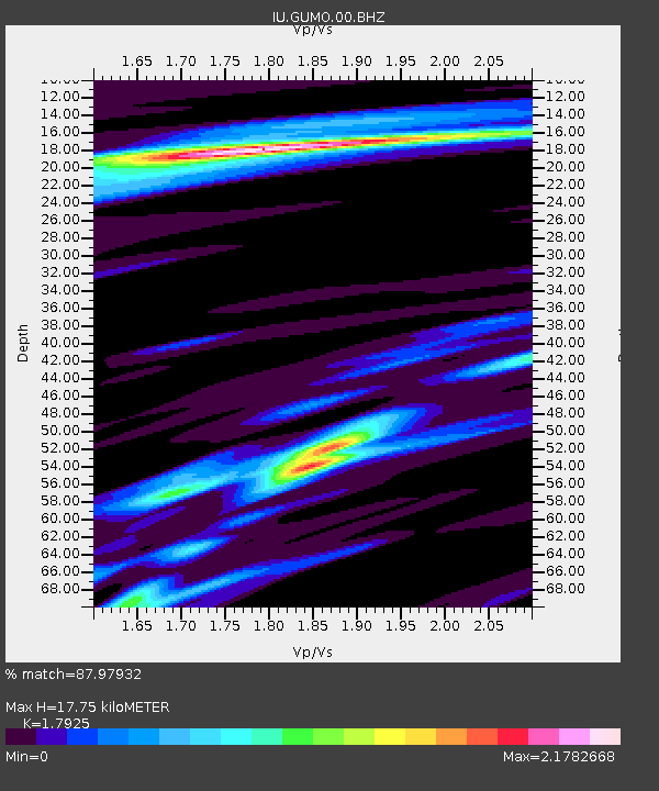
| Estimated Moho Depth: |
17.75 km |
| Estimated Crust Vp/Vs: |
1.79 |
| Assumed Crust Vp: |
4.802 km/s |
| Estimated Crust Vs: |
2.679 km/s |
| Estimated Crust Poisson's Ratio: |
0.27 |
|
| Radial Match: |
87.97932 % |
| Radial Bump: |
326 |
| Transverse Match: |
62.14911 % |
| Transverse Bump: |
400 |
| SOD ConfigId: |
626651 |
| Insert Time: |
2014-04-26 20:43:55.584 +0000 |
| GWidth: |
2.5 |
| Max Bumps: |
400 |
| Tol: |
0.001 |
|

Signal To Noise
| Channel | StoN | STA | LTA |
| IU:GUMO:00:BHZ:20140412T20:20:16.468999Z | 34.13427 | 5.0410075E-5 | 1.4768173E-6 |
| IU:GUMO:00:BH1:20140412T20:20:16.468999Z | 20.741985 | 2.9389152E-5 | 1.416892E-6 |
| IU:GUMO:00:BH2:20140412T20:20:16.468999Z | 18.294456 | 2.0305903E-5 | 1.1099482E-6 |
| Arrivals |
| Ps | 3.1 SECOND |
| PpPs | 9.9 SECOND |
| PsPs/PpSs | 13 SECOND |


