You are here: Home > Network List > IU - Global Seismograph Network (GSN - IRIS/USGS) Stations List
> Station POHA Pohakuloa, Hawaii, USA > Earthquake Result Viewer
POHA Pohakuloa, Hawaii, USA - Earthquake Result Viewer

| Earthquake location: |
Solomon Islands |
| Earthquake latitude/longitude: |
-11.3/162.2 |
| Earthquake time(UTC): |
2014/04/12 (102) 20:14:39 GMT |
| Earthquake Depth: |
29 km |
| Earthquake Magnitude: |
7.6 MWW, 8.3 MI |
| Earthquake Catalog/Contributor: |
NEIC PDE/NEIC COMCAT |
|
| Network: |
IU Global Seismograph Network (GSN - IRIS/USGS) |
| Station: |
POHA Pohakuloa, Hawaii, USA |
| Lat/Lon: |
19.76 N/155.53 W |
| Elevation: |
1990 m |
|
| Distance: |
51.8 deg |
| Az: |
53.686 deg |
| Baz: |
237.047 deg |
| Ray Param: |
0.067114666 |
| Estimated Moho Depth: |
12.75 km |
| Estimated Crust Vp/Vs: |
1.93 |
| Assumed Crust Vp: |
5.195 km/s |
| Estimated Crust Vs: |
2.685 km/s |
| Estimated Crust Poisson's Ratio: |
0.32 |
|
| Radial Match: |
89.78924 % |
| Radial Bump: |
364 |
| Transverse Match: |
79.02929 % |
| Transverse Bump: |
400 |
| SOD ConfigId: |
626651 |
| Insert Time: |
2014-04-26 20:44:14.161 +0000 |
| GWidth: |
2.5 |
| Max Bumps: |
400 |
| Tol: |
0.001 |
|
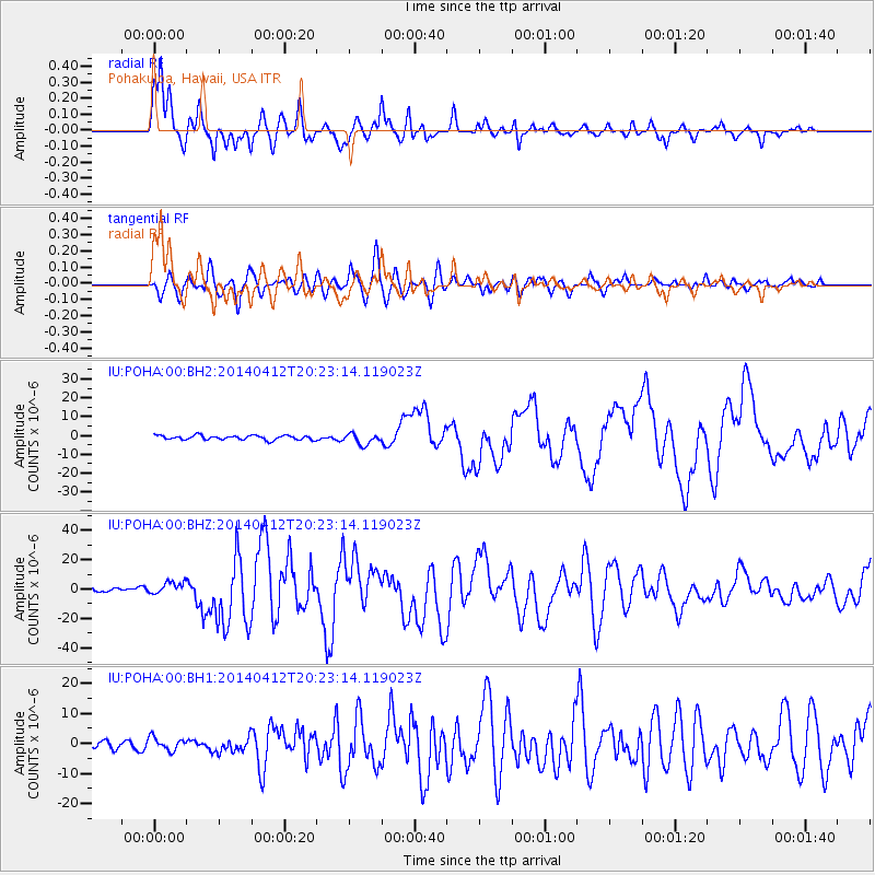
Signal To Noise
| Channel | StoN | STA | LTA |
| IU:POHA:00:BHZ:20140412T20:23:14.119023Z | 2.4187138 | 4.132679E-6 | 1.7086267E-6 |
| IU:POHA:00:BH1:20140412T20:23:14.119023Z | 1.2976253 | 2.1558817E-6 | 1.6614053E-6 |
| IU:POHA:00:BH2:20140412T20:23:14.119023Z | 2.5284553 | 2.8947736E-6 | 1.1448783E-6 |
| Arrivals |
| Ps | 2.4 SECOND |
| PpPs | 7.0 SECOND |
| PsPs/PpSs | 9.3 SECOND |


