You are here: Home > Network List > JP - Japan Meteorological Agency Seismic Network Stations List
> Station JHJ2 Hachijojima Island > Earthquake Result Viewer
JHJ2 Hachijojima Island - Earthquake Result Viewer
| Earthquake location: |
Solomon Islands |
| Earthquake latitude/longitude: |
-11.3/162.2 |
| Earthquake time(UTC): |
2014/04/12 (102) 20:14:39 GMT |
| Earthquake Depth: |
29 km |
| Earthquake Magnitude: |
7.6 MWW, 8.3 MI |
| Earthquake Catalog/Contributor: |
NEIC PDE/NEIC COMCAT |
|
| Network: |
JP Japan Meteorological Agency Seismic Network |
| Station: |
JHJ2 Hachijojima Island |
| Lat/Lon: |
33.12 N/139.81 E |
| Elevation: |
70 m |
|
| Distance: |
49.1 deg |
| Az: |
334.962 deg |
| Baz: |
150.356 deg |
| Ray Param: |
0.06888059 |
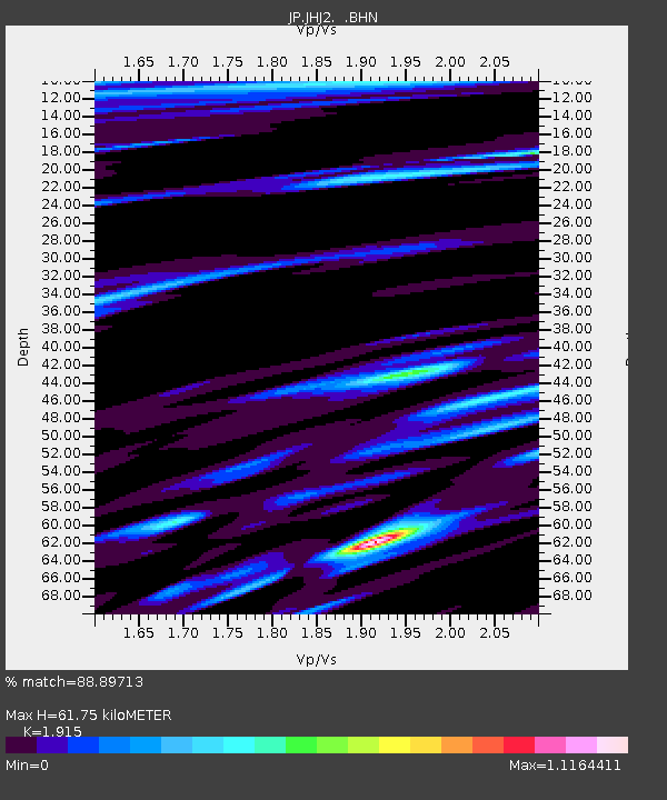
| Estimated Moho Depth: |
61.75 km |
| Estimated Crust Vp/Vs: |
1.91 |
| Assumed Crust Vp: |
4.662 km/s |
| Estimated Crust Vs: |
2.435 km/s |
| Estimated Crust Poisson's Ratio: |
0.31 |
|
| Radial Match: |
88.89713 % |
| Radial Bump: |
312 |
| Transverse Match: |
79.80447 % |
| Transverse Bump: |
400 |
| SOD ConfigId: |
626651 |
| Insert Time: |
2014-04-26 20:45:09.692 +0000 |
| GWidth: |
2.5 |
| Max Bumps: |
400 |
| Tol: |
0.001 |
|

Signal To Noise
| Channel | StoN | STA | LTA |
| JP:JHJ2: :BHZ:20140412T20:22:53.449987Z | 46.943157 | 6.0138274E-5 | 1.2810871E-6 |
| JP:JHJ2: :BHN:20140412T20:22:53.449987Z | 16.327717 | 2.561961E-5 | 1.5690871E-6 |
| JP:JHJ2: :BHE:20140412T20:22:53.449987Z | 11.624546 | 1.2308358E-5 | 1.0588249E-6 |
| Arrivals |
| Ps | 12 SECOND |
| PpPs | 38 SECOND |
| PsPs/PpSs | 50 SECOND |


